Current Weather Conditions
John A. Weeks III
Thursday, September 2, 2010, 8:24:54 PM CDT
Home 12 Easy Steps Random Topics About The Author Portal
Aviation Spacecraft Highways & Bridges Photo Tours Rail Fan

Google Search

 Maps  Groups
 Images  Search
  Home
  • 12 Easy Steps
  • Aviation
  • Spacecraft
  • Highways & Bridges
    » Bridge Photography
      - MSP River Bridges
      - C & D Canal
      - Illinois River
      - Minnehaha Creek
      - Minnesota River
      - Mississippi River
      - Missouri River
      - St. Croix River
      - St. Louis River
      - Wisconsin River
      - Cable Stayed Bridges
        › 21st Street Bridge
        › 180D Coatzacoalcos
        › Arthur DiTommaso
        › 6th Street Viaduct (N)
        › 6th Street Viaduct (S)
        › Badger Road Bridge
        › Beach Road Bridge
        › Big Rock Bridge
        › CR-149 Bluff Dale
        › Cross Seminole Trail
        › Sen Wm V. Roth Jr.
        › First Avenue Skyway
        › Dames Point Bridge
        › Henn Co Medical Ctr
        › Alex Fraser Bridge
        › Bob Graham Skyway
        › Glass City Skyway
        › Varina-Enon Bridge
        › Hale Boggs Mem Br
        › Charles W. Dean Br
        › Ronald Reagan Mem
        › Bunker Hill Mem Br
        › Bill Emerson Mem Br
        › IN-46 East Fork Br
        › Ironton Russell Br
        › Indian River Inlet
        › John J Audubon Br
        › Lane Avenue Bridge
        › Vancouver Skybridge
        › Martin Olav Sabo Br
        › MSP Airport Skyway
        › O'Connell Bridge
        › Pomeroy Mason Br
        › Ohio River Br (DT)
        › Ohio River Br (ES)
        › Pan American Hwy
        › La Plata River Bridge
        › Reiman Bridge
        › Rhythm City Sky Br
        › Sundial Bridge
        › Fred Hartman Bridge
        › Veterans Memorial Br
        › Arthur Ravenel Jr Br
        › Sidney Lanier Br
        › Talmadge Memorial
        › Penobscot Narrows Br
        › Weirton-Steubenville
        › William H. Natcher
        › US Grant Bridge
        › Quincy Bayview Br
        › The Great River Br
        › US-41/US-45 Ped Br
        › William H. Harsha
        › Clark Superbridge
        › Ben G Humphreys Br
        › Cochrane-Africatown
        › Ed Hendler Bridge
        › Frank Gatski Mem Br
        › Lake Underhill Br
      - McGilvray Road
      - I-35W Bridge Disaster
      - Miscellaneous Bridges
    » Road Geek Topics
  • Random Topics
  • Photo Tours
  • Rail Fan
  • About The Author
  • John's Portal
 
Site Search By JRank
Highways, Byways, And Bridge Photography
Badger Road Bridge
Badger Road UPRR Railroad Crossing At Madison
Town Of Madison, Wisconsin

Badger Road Bridge

• Bridge: Badger Road Bridge
• Structure ID: NBI B13057100000000
• City: Town Of Madison
• State: Wisconsin
• Country: USA
• Carries: East Badger Avenue
• Crosses: Union Pacific Railroad
• Date Opened: 2005
• Total Length: 100 Feet
• Longest Span: 100 Feet
• Tower Height: ??? Feet
• Deck Width: 34 Feet
• Number Of Lanes: 2
• Number Of Spans: 1
• Height Above Railroad: ??? Feet
• Traffic Count: 2,000 (2004 Estimate)
The Badger Road Bridge is located on the south side of the Madison, Wisconsin, South Beltline Highway just east of the US-14 (Park Street) interchange and just west of Rimrock Road. Badger Road predates the beltline. In fact, Badger Road was cut in two by the beltline, creating East Badger Road and West Badger Road. Businesses on East Badger Road suffered because it was hard to find the exit and streets to get to that location despite the location being highly visible to traffic.

This location is part of the Town Of Madison. The Township consisted of land that was south of the City of Madison. Over the years, the town was slowly eaten at the edges by the City of Madison as it grew. A great controversy erupted with the Town of Fitchburg incorporated into a city, and it started to annex parts of the Town of Madison. The problem erupted into lawsuits every few years, one of which when to the Supreme Court. The most recent plan is that the Town of Madison no longer serves a unique role given that the area is totally urbanized and surrounded by city on all sides. As a result, an agreement has been made where the Town of Madison will be dissolved in 2022, with the part south of the beltline going to the City of Fitchburg, and the part north of the beltline going to the City of Madison. The net result is that this bridge will then become owned by the City of Fitchburg.

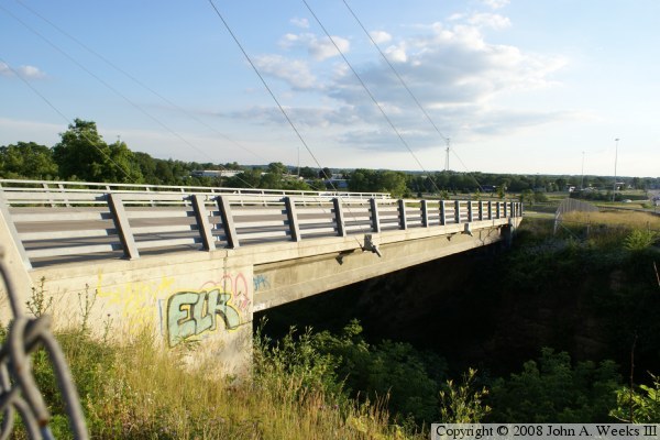
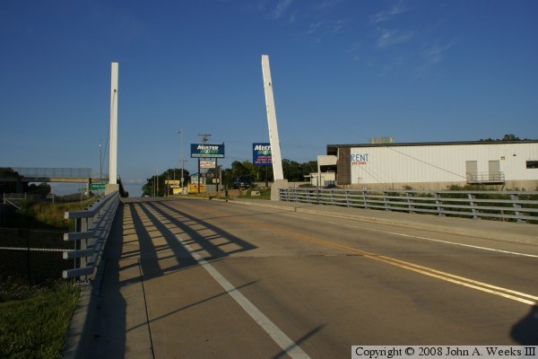
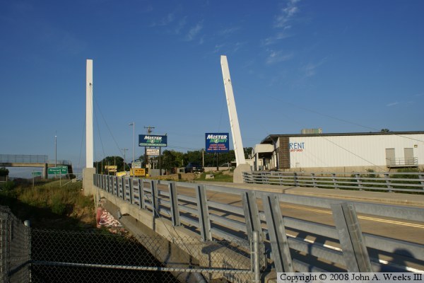
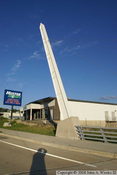
In the early 2000s, the Town of Madison wished to redevelop the area between US-14 and its eastern border. A plan was developed to build a corporate campus on the east side, improve traffic flow to the local businesses, and improve utilities to the housing stock. A key element was this bridge. East Badger Road simply ended at the railroad tracks. The corporate campus tenants wanted a second access point, preferably one that connected to US-14 to provide an alternate when the beltline was backed up. The solution was found by building this bridge, and connecting to an access road on the west side of the railroad tracks. This west side access road turned to the south and connected to US-14 by an freeway interchange.


Badger Road Bridge
Badger Road Bridge
Badger Road Bridge
Badger Road Bridge
Badger Road Bridge

Made With Macintosh
Authored by John A. Weeks III, Copyright © 1996—2010, all rights reserved.
For further information, contact: john@johnweeks.com