Current Weather Conditions
John A. Weeks III
Friday, July 26, 2024, 10:06:55 PM CDT
Home Photo Tours Rail Fan 12 Easy Steps
Aviation Spacecraft Highways & Bridges About The Author
 
Google Search
Maps   Groups   Images   Search
 
  Home
  • 12 Easy Steps
  • Aviation
  • Spacecraft
  • Highways & Bridges
    » Bridge Photography
      - MSP River Bridges
      - C & D Canal
      - Illinois River
      - Minnehaha Creek
      - Minnesota River
      - Mississippi River
      - Missouri River
      - St. Croix River
      - St. Louis River
      - Wisconsin River
      - Best Miss River Photos
      - Cable Stayed Bridges
        › Arthur Ravenel Jr Br
        › Bill Emerson Mem Br
        › Clark Bridge
        › Cochrane-Africatown
        › Dames Point Bridge
        › Ed Hendler Bridge
        › Frank Gatski Mem Br
        › Fred Hartman Bridge
        › Glass City Skyway
        › Greenville Bridge
        › Hale Boggs Mem Br
        › John J Audubon Br
        › O'Connell Bridge
        › Penobscot Narrows Br
        › Quincy Bayview Br
        › Sen C Bond Bridge
        › Sen Wm V. Roth Jr. Br
        › Sunshine Skyway Br
        › Sidney Lanier Bridge
        › Talmadge Memorial Br
        › The Great River Bridge
        › US Grant Bridge
        › Varina-Enon Bridge
        › Veterans Memorial Br
        › Weirton-Steubenville
        › Wm H. Natcher Bridge
        › Wm H. Harsha Bridge
        › Zakim/Bunker Hill Br
          — — — — — — — —
        › Alex Fraser Bridge
        › Centennial Bridge
        › Coatzacoalcos II Bridge
        › La Plata River Bridge
        › Vancouver Skybridge
          — — — — — — — —
        › Indian River Inlet
        › Pomeroy-Mason Bridge
        › Ronald Reagan Mem
          — — — — — — — —
        › Charles W. Dean Br
        › Ironton-Russell Br
        › Ohio R Br (Downtown)
        › Ohio R Br (East End)
          — — — — — — — —
        › 6th Street Viaduct (N)
        › 6th Street Viaduct (S)
        › 21th Street Bridge
        › Arthur DiTommaso Br
        › Badger Road Bridge
        › Beach Road Bridge
        › East Fork Bridge
        › Lake Underhill Br
        › Lane Avenue Bridge
          — — — — — — — —
        › Bluff Dale Bridge
          — — — — — — — —
        › Bob Kerrey Ped Br
        › Big Rock Creek Br
        › Cross Seminole Trail
        › First Avenue Skyway
        › Gold Strike Park Br
        › Hennepin Co Med Ctr
        › Keeper Of The Plains
        › Martin Olav Sabo Br
        › Millennium Bridge
        › Mortensen Plaza
        › MSP Airport Skyway
        › Platte River Bridge
        › Reiman Bridge
        › Rhythm City Sky Br
        › Sundial Bridge
        › US-41/45 Ped Bridge
      - McGilvray Road Bridges
      - I-35W Bridge Disaster
      - Miscellaneous Bridges
      - Madison County Bridges
      - Hist Br Weekend 2013
    » Road Geek Topics
  • Photo Tours
  • Rail Fan
  • About The Author
 
Site Search By JRank
Highways, Byways, And Bridge Photography
Indian River Inlet Bridge
DE-1 Indian River Inlet Crossing At Bethany Beach
Bethany Beach, Delaware
— Under Construction —

Indian River Inlet Bridge

• Bridge: Indian River Inlet Bridge
• Structure ID: Not Yet Assigned
• City: Bethany Beach
• State: Delaware
• Country: USA
• Carries: DE-1
• Crosses: Indian River
• Date Opened: Estimated January 2012
• Total Length: 2,600 Feet (Without Approach Spans)
• Longest Span: 1,300 Feet
• Tower Height: 240
• Deck Width: 100 Feet (Estimated)
• Number Of Lanes: 4
• Number Of Spans: 1
• Height Above Water: 45 Feet
• Traffic Count: TBD
The Indian River Inlet is a water opening in a barrier island between the Atlantic Ocean and the Indian River Bay, which is fed by the Indian River. The inlet has traditionally migrated north and south over a 2 mile long section of the barrier island. Since the inlet moved often, it remained rather shallow. In order to bridge the inlet, the gap had to be stabilized. This was done first by dredging, which started in 1928, and later the construction of jetties in 1938. The jetties constrained the width of the inlet. Since the water could not scour the inlet wider, it started to deepen the inlet.

A new bridge was built in 1965, with a 2nd parallel span added in 1976. That bridge has piers sitting in the water on the sides of the channel. A survey in 1980 revealed evidence of significant scouring. The channel has since grown from 28 feet deep to over 100 feet deep, and is in danger of undercutting the bridge piers. The Delaware DOT has been struggling to keep the bridge safe since that time.

A new bridge over the inlet was designed in the 2000s. It was to be a landmark bridge with a single reinforced concrete arch, a wide highway deck, and regional trail bridge suspended on cables. The bridge project started in 2005 with grading, approaches, and retaining walls. The bridge was designed so that it would land on gravel ramps built up to the edge of the inlet.

Once the new bridge work was underway, the bridge structure project was sent out to bid. The bids were expected to be in the $120-million range, but came back in the $200-million dollar range. There simply was not enough money in the budget to complete this bridge as designed. In addition, the US Army Corps of Engineers determined that the jetties were in danger of failing, and that could cause the inlet to widen considerably.

At that point, Delaware DOT had to go back to the drawing board. They proposed to recast the project as a design and build project. Using this method, vendors proposed to do both the bridge design and build the bridge to their design. The final vendor would be picked both on their skills in building bridges as well as the merits of the design. The winning design is a large cable stayed bridge. The low bid was $149-million, within a few dollars of the $150-million budget for the project.

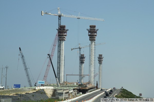
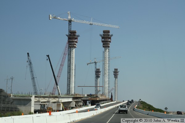
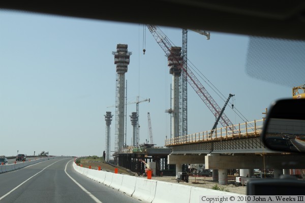
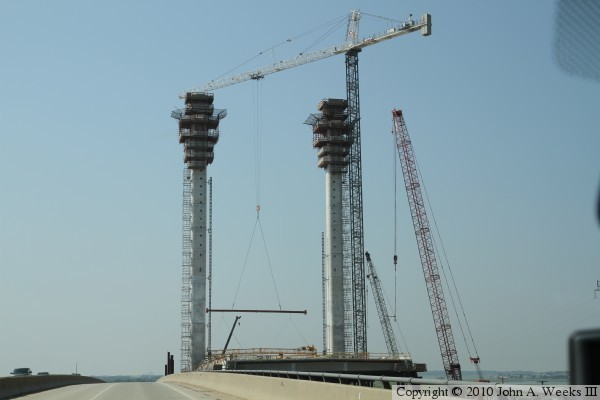
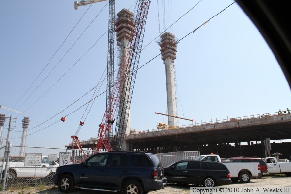
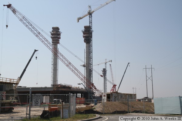
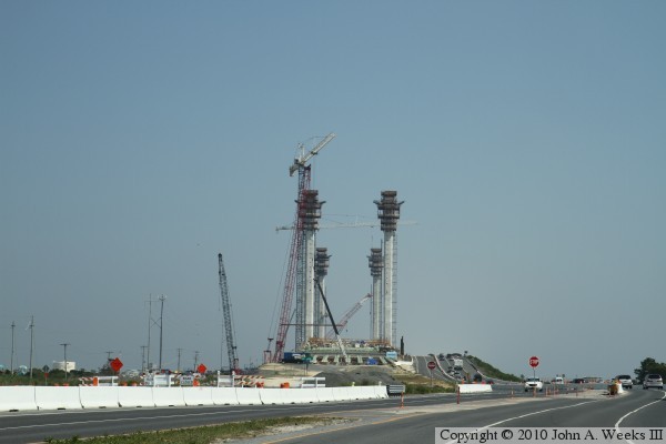
The new bridge will have 4 free-standing towers reaching 240 into the air, with 2 towers on each side of the inlet. Each tower will support one plane of cables, with two parallel cable planes in series supporting a 1,300 foot long main span. This puts 900 feet of the bridge over water, and 1,700 feet over land, more than enough distance to accommodate a wider inlet channel. The down side of the new design is that all of the work that Delaware DOT has invested in the project so far is no longer needed, and will have to be removed.

Update—A serious problem with a key piece of machinery known as a form traveler will delay the bridge opening nearly a year. The machine was built before final specs were known, and it is not strong enough to support the weight of the road segments. In addition, cracks have been found in some deck segments that have already been erected. Meanwhile, the existing highway bridge is close to failure due to erosion at the north approach. The bridge was closed for a period of time in November, 2011, for repairs.

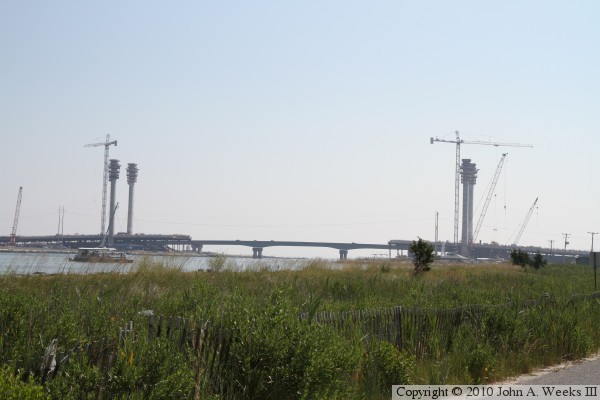
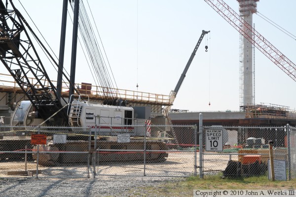
The photo above is a view of the bridge construction site as we approach the south end of the project traveling northbound on highway DE-1. These construction photos are from July, 2010. The main bridge towers have recently been completed, and work is underway to start attaching stay cables and hanging the segments that will make up the main bridge span.


Indian River Inlet Bridge
These two photos are passing the bridge site heading northbound on highway DE-1. The photo above is just approaching the bridge approach span, while the photo below is starting the climb up the approach to the old bridge.

Indian River Inlet Bridge
These two photos are traveling southbound on highway DE-1. The photo above is approaching the embankment leading to the existing highway bridge. The photo below is a view of the south bridge towers as seen from mid-span of the existing DE-1 bridge.

Indian River Inlet Bridge
The image above is a rendering of the new bridge as the cable stayed span is proposed to look when completed. The photo below is looking east into the morning sun from the state park located along the Indian River Inlet. This gives a view of just how long the main span will be. It doesn't look anywhere near that long as you pass it on the highway.

Indian River Inlet Bridge
These two photos are views from ground level on the south side of the bridge project. The photo above is looking northeast towards the work happening on the south bridge towers. The photo below is looking north along the west side of the project.

Indian River Inlet Bridge
These two photos are views from ground level on the north side of the bridge project. The photo below is a view of the cranes working near the north bridge towers. The photo below is a closer view of one of the track mounted cranes.

Indian River Inlet Bridge

Made With Macintosh
Authored by John A. Weeks III, Copyright © 1996—2016, all rights reserved.
For further information, contact: john@johnweeks.com