As far as I can determine, there are four structures at the Upper Saint
Anthony Falls Power Plant that I would consider to be bridges. This
includes the following:
- Bridge #1: Vehicle bridge across the powerhouse intake channel.
- Bridge #2: Walkway across the powerhouse tailrace outlet.
- Bridge #3: Vehicle bridge across the laboratory outlet channel.
- Bridge #4: Walkway to the new Water Power Park.
These bridges do not cross the main channel of the Mississippi River.
In addition, there may be more bridges on the site that I have not
been able to confirm or photograph as follows:
- Bridge #5: Walkway between laboratory and powerhouse.
- Bridge #6: Walkway across the laboratory outlet channel.
- Bridge #7: Vehicle bridge leading to storage shed.
There is a lot of activity going on in the area around the upper falls
power plant. The main activity is generation of electrical power. The
NSP (Northern States Power, owned by Xcel Energy) powerhouse was built in
1908 to supply power for the rapidly expanding street car system. The
powerhouse was connected to the commercial power grid after the demise
of the street car system, and generates 12-megawatts of electricity using
5 generators. The current generators date back to 1954. NSP also rebuilt
the dam in front of the powerhouse, replacing it with a sheet pile and
earthen structure in 2001.
Another major activity on Hennepin Island is the Saint Anthony Falls
Laboratory, a facility managed and operated by the Institute of Technology
at the University of Minnesota. The lab was founded in 1938 to be a
research facility to study water flow. Its initial goal was to study
dam projects, but today, that focus has shifted to a vast array of
fluid flow and gas research projects, including the study of the removal
of dams. The lab building consists of 5 floors, with 2 above the water
level and 3 below the water level. In addition, the lab maintains and
outdoor test channel and an outdoor stream simulation facility.
The final activity on Hennepin Island is new starting in 2007. In order
for NSP to renew its hydropower license, they had to submit a plan for
how the river area would be used for recreational purposes. NSP came up
with the idea for Water Power Park. They installed a bridge to allow the
general public to have access to the northern part of Hennepin Island.
NSP further installed a number of walkways and viewing platforms to get
spectacular up and close views of the river as it flows over the various
levels of the upper Saint Anthony Falls dam. NSP has created a wonderful
park that is a must-see for anyone visiting the falls area. The photo
above is a view of the walkway bridge that leads from Main Street to the
park.
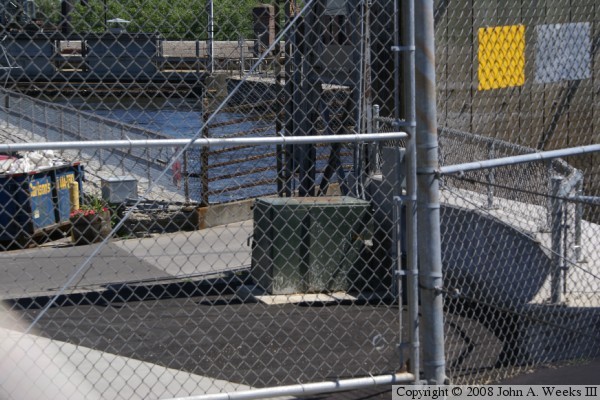
Bridge #1 is located in a spot where it is not possible to photograph
without doing some serious and risky trespassing. The photo above,
shot through a chain-link fence, shows the sidewalk and handrail
leading to a bridge that crosses the powerhouse intake canal. The walkway
starts in the center of the photo, and heads to the right. The photo
below shows the channel that the bridge crosses, and the wooden doors
that block the view of the bridge.
For hardcore bridge fans, we may have a glimpse of Bridge #5 in the photo
above. If you look at the top center of the photo, there appears to be
a short chimney. Just in front of the chimney is a handrail. That hand
rail would be part of Bridge #5, if that bridge actually exists.
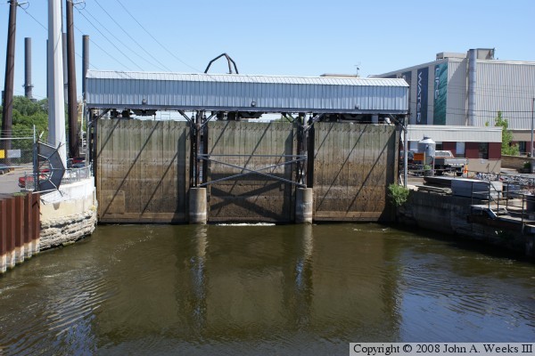
These two photos are views of Bridge #3. This bridge crosses an outflow
channel leaving the Saint Anthony Falls Laboratory. It carries the outflow
water from the Saint Anthony Falls Laboratory and acts as an overflow valve
for the powerplant intake. The lab is managed by the University of Minnesota,
and is used to model flows of water, liquids, and gasses. The water flowing
out of the outflow channel falls about 30 feet down to river level. It is
such a nice waterfall, yet it is hardly known despite being in the heart of
the city.
The photo above shows the top of the waterfall and the outlet of the channel.
The bridge is located at the top of the outlet. The photo below is a view
looking across the bridge. This view was taken through a chain link fence.
The waterfall drops off to the right.
These two photos are Bridge #4, a new bridge that was just installed in
late 2006. It crosses the power plant intake canal and connects Main Street
to Water Power Park, a park that sits on Hennepin Island in the middle of
the river. This park was built by Xcel Energy, the former Northern States
Power Company. They were required to submit a recreational use plan for the
power plant area as part of the license process for the hydropower station.
They came up with a fantastic plan to open this formerly off-limits area to
the public. Xcel Energy states that there are two overlooks to the main
falls, one that is spectacular, and another that is even better. The parked
opened in June of 2007.
The photo above looks across the length of the bridge as seen from inside
Water Power Park. The photo below is a view of Bridge #4 taken from Main
Street. The mills on the Minneapolis side of the river are in the background.
These mills have been rebuilt into office space, condos, and museums. There
has been no operating mills in downtown Minneapolis for many years.
The photo above shows the walkway bridge (Bridge #2) that is located just
in front of the power house spanning the outlet and spillway. The
Hennepin Island power station is home to five hydropower generators.
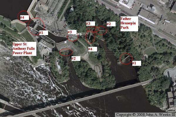
The image below is an aerial photo of the Saint Anthony side of the upper falls.
The left side of the photo shows the power plant area, while the right
side shows Father Hennepin Bluffs Park. The locations of the four powerplant
area bridges are noted. There may be two more walkways and another bridge
that cross Mississippi River water, but I would need somehow arrange a visit
to the site to be sure.