Current Weather Conditions
John A. Weeks III
Saturday, July 27, 2024, 3:54:00 AM CDT
Home Photo Tours Rail Fan 12 Easy Steps
Aviation Spacecraft Highways & Bridges About The Author
 
Google Search
Maps   Groups   Images   Search
 
  Home
  • 12 Easy Steps
  • Aviation
  • Spacecraft
  • Highways & Bridges
    » Bridge Photography
      - MSP River Bridges
        › 10th Avenue Bridge
        › Arcola High Bridge
        › Betty Adkins Bridge
        › Bloomington Ferry
        › Bloomington Fry Tr
        › BNSF RR Bridge
        › Boom Island Foot Br
        › Broadway Avenue Br
        › C&NW Bridge (1)
        › C&NW Bridge (2)
        › Camden Bridge
        › Cedar Avenue Bridge
        › Cedar Ave Br (Old)
        › Cedar Ave Bicycle Br
        › Cedar Bend RR Br
        › Chaska Bridge (Old)
        › Chaska Swing Bridge
        › Chaska Trestle
        › Coon Rapids Dam
        › CP RR Bridge
        › Dan Patch Line Br
        › Dartmouth Bridge
        › East Channel Bridge
        › East Channel RR Br
        › East River Flats Br
        › Endless Bridge
        › F. W. Cappelen Mem
        › Father Henn Bluffs
        › Father Louis Henn Br
        › Ferry Street Bridge
        › First Avenue Bridge
        › Fort Road Bridge
        › Fort Snelling Br (Old)
        › Fort Snelling High Br
        › Great Western Bridge
        › Grey Cloud Channel
        › Grey Cloud Island Br
        › Grey Cloud Trail Br
        › Hastings High Bridge
        › Hastings Spiral Br
        › Holmes St Ped Bridge
        › Highway 243 Bridge
        › I-35W Bridge
        › I-35W Bridge (Old)
        › I-494 Bridge
        › I-694 Bridge
        › Interstate Bridge
        › Intercity Bridge
        › L St. Anthony F L&D
        › Lafayette Bridge
        › Lake Street Bridge
        › Lewis Street Bridge
        › Lexington Bridge
        › Lions Levee Pk Foot
        › Lock & Dam #1
        › Lock & Dam #2
        › Long Meadow Bridge
        › Lower Bridge
        › Lowry Bridge (Old)
        › Meeker Island L&D
        › Mendota Bridge
        › Merriam Street Br
        › Mill Ruins Park Br
        › Milwaukee Road Br
        › M&StL Bridge
        › Miss River Bridge 15
        › MN-101 Bridge
        › MN-41 Backchannel
        › MN-41 Back Ch (Old)
        › MN-41 Bridge
        › New Saint Croix Br
        › New Trunk-41 Bridge
        › Nicollet Island RR Br
        › North Miss Park Pier
        › NP Bridge #9
        › NP RR Bridge
        › Pike Island Bridge
        › Plymouth Bridge
        › Point Douglas DB
        › Raspberry Island Br
        › Richard P. Braun Br
        › Robert Street
        › Rock Island Swing Br
        › Runway 30 Light Br
        › Short Line Bridge
        › Smith Avenue High
        › Southeast Steam Plant
        › St. Anthony Falls Br
        › St. Anthony Falls Lab
        › St. Anthony Falls PP
        › St. Croix Boom Site
        › St. Croix Falls Dam
        › Stillwater Lift Br
        › Stone Arch Bridge
        › Third Avenue Bridge
        › Toll Bridge (Old)
        › U St. Anthony F L&D
        › US-8 Bridge
        › Wabasha Street Bridge
        › Wakota Bridge
        › Wakota Bridge (Old)
        › Walnut Street CW
        › Washington Ave Br
        › WI Central RR Br
        › WI Central RR Ruins
        › Wright Co Hwy 42
      - C & D Canal
      - Illinois River
      - Minnehaha Creek
      - Minnesota River
      - Mississippi River
      - Missouri River
      - St. Croix River
      - St. Louis River
      - Wisconsin River
      - Best Miss River Photos
      - Cable Stayed Bridges
      - McGilvray Road Bridges
      - I-35W Bridge Disaster
      - Miscellaneous Bridges
      - Madison County Bridges
      - Hist Br Weekend 2013
    » Road Geek Topics
  • Photo Tours
  • Rail Fan
  • About The Author
 
Site Search By JRank
Highways, Byways, And Bridge Photography
Lower Bridge
Historic 6th Avenue Mississippi River Crossing
Minneapolis, MN

Lower Bridge

• Structure ID: N/A.
• Location: River Mile 853.4.
• River Elevation: 750 Feet.
• Highway: SE 6th Avenue, 10th Avenue S.
• Daily Traffic Count: 0 (Bridge Is Removed).
• Bridge Type: Iron Deck Truss.
• Length: Approximately 1,100 Feet.
• Width: 2 Traffic Lanes.
• Navigation Channel Width: 200 Feet (Estimated).
• Height Above Water: 32 Feet To Low Iron, 60 Feet To Deck (Estimated).
• Date Built: 1874.
The first road bridge built in the Twin Cities area over the Mississippi River was the First Bridge built for Hennepin Avenue in 1855. Two more bridges followed in 1857, the Upper Bridge (at Plymouth Avenue) and the Lower Bridge (near the present day Stone Arch Bridge). A large flood washed away both the Upper Bridge and Lower Bridge on June 3, 1859. Remarkably, the First Bridge was left standing, primarily due to it being a suspension bridge and having no piers exposed to the raging flood waters.

At that point in history, Minneapolis was on the west bank of the Mississippi River, which was the south side of the river in the falls area. The north side of the river was occupied by the City of Saint Anthony. In 1872, the two cities agreed to merge, with the unified city keeping the name Minneapolis. As part of the merger deal, the city of Minneapolis agreed to rebuild the Upper Bridge and the Lower Bridge. Previous bridges were privately owned and charged tolls for users. The new bridges would be paid for by $230,000 in public bonds.

The new Lower Bridge was built by the King Bridge Company of Topeka, Kansas. The bridge featured masonry piers and a long iron truss to support a narrow two lane wagon path across the river. The new lower bridge opened in 1874 after 15 years of the First Bridge being the only road bridge to cross the Mississippi River in Minneapolis. Street cars became popular in the 1890s, and a street car line was built across the Lower Bridge prior to the turn of the century.

The Lower Bridge was lightly built by current standards. The iron structure was not as strong as an equivalent steel structure. The bridge was not built for the weight of the street cars, and it was not designed to withstand the pounding from automobile traffic that developed in the 20th century. As a result, the Lower Bridge was closed in 1934. It stood until 1943, when it was demolished as part of a World War II scrap iron drive.

The lower bridge connected to 6th Avenue SE on the north side of the river. The present day location of the bridge abutment would be just a few feet downriver from the traffic cul-du-sac at the entrance of the Stone Arch Bridge. The south end of the bridge connected to 10th Avenue S. That location would be just downriver from the location of the new Guthrie Theater. As a result its connection to 10th Avenue S, the Lower Bridge was often referred to as the 10th Avenue Bridge. This may be a bit confusing since the current 10th Avenue Bridge is the bridge once known as the Cedar Avenue Bridge. Even more confusing is the current Cedar Avenue Bridge is the structure on MN-77 that crosses the Minnesota River near the Mall of America.

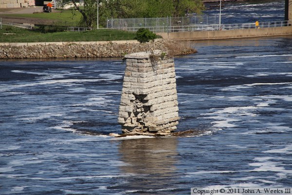
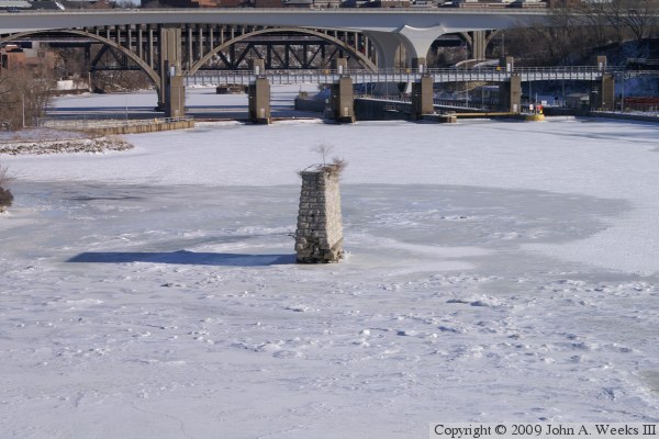
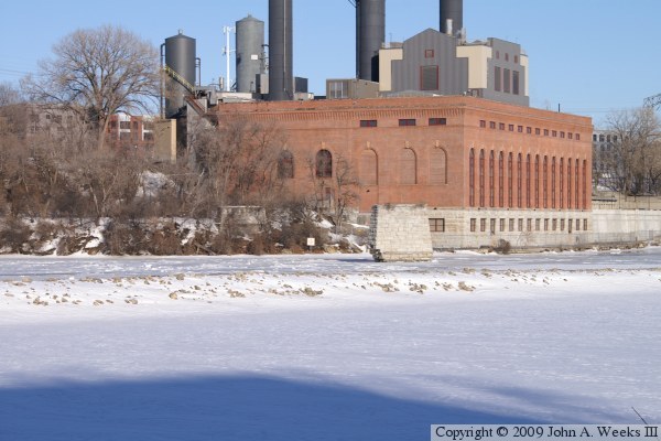
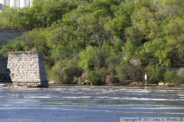
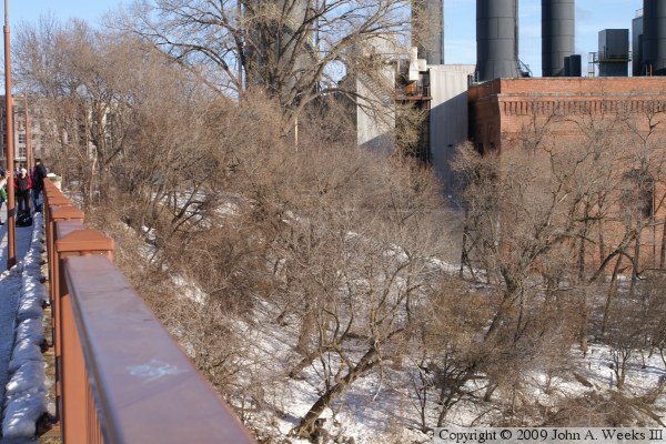
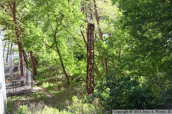
There appears to be no evidence of the lower bridge on the south side of the river. Two bridge piers remain on the north side of the river. One pier is in the water near the University Steam Plant, while the other pier is in the weeds on shore next to the steam plant. The photo above shows the two remaining piers. The photo below is a public domain image of the Lower Bridge from early in the 1900s.


Lower Bridge
Lower Bridge
The photo above is a view of the pier that is located in the Mississippi River channel. The vantage point is the Endless Bridge at the Guthrie Theater, located on the south side of the river. The photo below is the same bridge pier as seen from the deck of the Stone Arch Bridge. It appears that additional stones have fallen from the pier over the two year interval between these photos.

Lower Bridge
Lower Bridge
These two photos show the mid-river pier that remains from the Lower Bridge. The pier appears to be slowly eroding away at its base. The photo above is a view from the Stone Arch Bridge, while the photo below is a view from the Mill Ruins Park.

Lower Bridge
Lower Bridge
The photo above is a view of the northernmost of the two piers that still remain from the Lower Bridge. The pier is located next to the University of Minnesota Southeast Steam Plant in the Lower River Flats area. The vantage point is the deck of the Stone Arch Bridge. The photo below is a view of both remaining piers as seen looking across the Mississippi River from the access road leading to the upstream side of the Lower Saint Anthony Lock & Dam.

Lower Bridge
Lower Bridge
The photo above is a view of the area where the northern abutment of the bridge once stood. The area is now a garden area maintained by the city. There appears to be no structure remaining from the abutment, however, there does appear to be some kind of old-looking steel structure hidden in the trees. The photo below is a spring photo from two years later, showing a steel tower. I don't know if this was connected with the Lower Bridge, but it at least looks to be a possibility.

Lower Bridge

Made With Macintosh
Authored by John A. Weeks III, Copyright © 1996—2016, all rights reserved.
For further information, contact: john@johnweeks.com