Current Weather Conditions
John A. Weeks III
Friday, July 26, 2024, 11:21:15 PM CDT
Home Photo Tours Rail Fan 12 Easy Steps
Aviation Spacecraft Highways & Bridges About The Author
 
Google Search
Maps   Groups   Images   Search
 
  Home
  • 12 Easy Steps
  • Aviation
  • Spacecraft
  • Highways & Bridges
    » Bridge Photography
      - MSP River Bridges
        › 10th Avenue Bridge
        › Arcola High Bridge
        › Betty Adkins Bridge
        › Bloomington Ferry
        › Bloomington Fry Tr
        › BNSF RR Bridge
        › Boom Island Foot Br
        › Broadway Avenue Br
        › C&NW Bridge (1)
        › C&NW Bridge (2)
        › Camden Bridge
        › Cedar Avenue Bridge
        › Cedar Ave Br (Old)
        › Cedar Ave Bicycle Br
        › Cedar Bend RR Br
        › Chaska Bridge (Old)
        › Chaska Swing Bridge
        › Chaska Trestle
        › Coon Rapids Dam
        › CP RR Bridge
        › Dan Patch Line Br
        › Dartmouth Bridge
        › East Channel Bridge
        › East Channel RR Br
        › East River Flats Br
        › Endless Bridge
        › F. W. Cappelen Mem
        › Father Henn Bluffs
        › Father Louis Henn Br
        › Ferry Street Bridge
        › First Avenue Bridge
        › Fort Road Bridge
        › Fort Snelling Br (Old)
        › Fort Snelling High Br
        › Great Western Bridge
        › Grey Cloud Channel
        › Grey Cloud Island Br
        › Grey Cloud Trail Br
        › Hastings High Bridge
        › Hastings Spiral Br
        › Holmes St Ped Bridge
        › Highway 243 Bridge
        › I-35W Bridge
        › I-35W Bridge (Old)
        › I-494 Bridge
        › I-694 Bridge
        › Interstate Bridge
        › Intercity Bridge
        › L St. Anthony F L&D
        › Lafayette Bridge
        › Lake Street Bridge
        › Lewis Street Bridge
        › Lexington Bridge
        › Lions Levee Pk Foot
        › Lock & Dam #1
        › Lock & Dam #2
        › Long Meadow Bridge
        › Lower Bridge
        › Lowry Bridge (Old)
        › Meeker Island L&D
        › Mendota Bridge
        › Merriam Street Br
        › Mill Ruins Park Br
        › Milwaukee Road Br
        › M&StL Bridge
        › Miss River Bridge 15
        › MN-101 Bridge
        › MN-41 Backchannel
        › MN-41 Back Ch (Old)
        › MN-41 Bridge
        › New Saint Croix Br
        › New Trunk-41 Bridge
        › Nicollet Island RR Br
        › North Miss Park Pier
        › NP Bridge #9
        › NP RR Bridge
        › Pike Island Bridge
        › Plymouth Bridge
        › Point Douglas DB
        › Raspberry Island Br
        › Richard P. Braun Br
        › Robert Street
        › Rock Island Swing Br
        › Runway 30 Light Br
        › Short Line Bridge
        › Smith Avenue High
        › Southeast Steam Plant
        › St. Anthony Falls Br
        › St. Anthony Falls Lab
        › St. Anthony Falls PP
        › St. Croix Boom Site
        › St. Croix Falls Dam
        › Stillwater Lift Br
        › Stone Arch Bridge
        › Third Avenue Bridge
        › Toll Bridge (Old)
        › U St. Anthony F L&D
        › US-8 Bridge
        › Wabasha Street Bridge
        › Wakota Bridge
        › Wakota Bridge (Old)
        › Walnut Street CW
        › Washington Ave Br
        › WI Central RR Br
        › WI Central RR Ruins
        › Wright Co Hwy 42
      - C & D Canal
      - Illinois River
      - Minnehaha Creek
      - Minnesota River
      - Mississippi River
      - Missouri River
      - St. Croix River
      - St. Louis River
      - Wisconsin River
      - Best Miss River Photos
      - Cable Stayed Bridges
      - McGilvray Road Bridges
      - I-35W Bridge Disaster
      - Miscellaneous Bridges
      - Madison County Bridges
      - Hist Br Weekend 2013
    » Road Geek Topics
  • Photo Tours
  • Rail Fan
  • About The Author
 
Site Search By JRank
Highways, Byways, And Bridge Photography
Runway 30-Left Light Structure
Former Light Structure Minnesota River Crossing
Minneapolis, MN

Runway 30-Left Light Structure

• Structure ID: N/A.
• Location: River Mile 3.5.
• River Elevation: 686 Feet.
• Structure: Aircraft Landing Lights Support Structure.
• Structure Type: Steel Truss.
• Length: 415 Feet (Estimated).
• Width: 24 Feet (Estimated).
• Navigation Channel Width: 120 Feet.
• Height Above Water: 90 Feet.
• Date Built: Unknown, Removed In 2005.
Runway 30-Left is the most heavily used runway at the Minneapolis Saint Paul International Airport, one of the busiest airports in the world. Runway 30-Left has historically been a critical runway since its 10,000 foot length was the longest at MSP. The runway is situated such that there is a steep slope leading from the southeast end of the runway down to the Minnesota River. The airport needed to maintain a set of strobe lights to assist aircraft who were landing in fog or other types of bad weather. These lights needed to be located at a precise distance from the end of the runway, and at a precise elevation. As it happened, some of those lights needed to be placed directly above the Minnesota river. A light bridge was the only way to place those lights at the right distance from the runway and at the proper height above the river.

With the opening of the new north-south runway in 2006, the strobe lights were moved to a location crossing I-494 just east of the Mall Of America. At that time, the light structure bridge was removed, and the support on the west side of the river was replaced with a free-standing tower.

For most of its life, runway 30 Left was known as 29 Left. The Left part means that it is the left runway of two parallel runways. The number is the compass heading of the runway less the units digit. As a result, runway 30 Left points towards the compass heading 300 degrees. So, why did the compass heading of the runway change from 290 degrees to 300 degrees in the late 1990s? The runway did not change heading. Rather, the magnetic north pole moved. In fact, it moved just enough that a number of airport runways had to be updated in a similar manner.

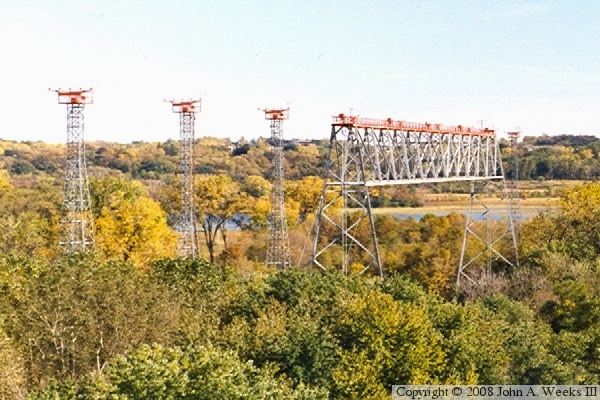
The photo above, taken during the fall colorama season in the late 1980s, shows the light structure span across the Minnesota River.


Runway 30-Left Light Structure
The aerial photo above shows the location of the Runway 30-Left Light Structure. The divided highway is Minnesota-5 on the east side of the Minneapolis Saint Paul International Airport. The end of Runway 30-Left is in the upper left side of the photo, while Fort Snelling State Park is in the upper right corner. The photo below shows the base of the light tower on the end of the structure nearest to the airport runway. These two images were provided by the US Army Corps of Engineers.

Runway 30-Left Light Structure
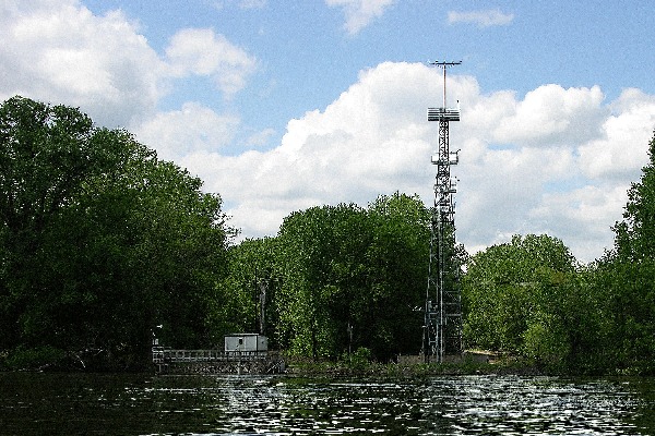
The photo above shows the post-2005 configuration from the river level. The light tower has been removed, and additional freestanding light towers have been installed. This photo was provided by the State of Minnesota DNR. The final photo is a view of the new runway light towers as seen from an overlook on the east side of the river valley using a telephoto lens.

Runway 30-Left Light Structure

Made With Macintosh
Authored by John A. Weeks III, Copyright © 1996—2016, all rights reserved.
For further information, contact: john@johnweeks.com