Current Weather Conditions
John A. Weeks III
Friday, April 19, 2024, 1:46:00 AM CDT
Home Photo Tours Rail Fan 12 Easy Steps
Aviation Spacecraft Highways & Bridges About The Author
 
Google Search
Maps   Groups   Images   Search
 
  Home
  • 12 Easy Steps
  • Aviation
  • Spacecraft
  • Highways & Bridges
    » Bridge Photography
      - MSP River Bridges
        › 10th Avenue Bridge
        › Arcola High Bridge
        › Betty Adkins Bridge
        › Bloomington Ferry
        › Bloomington Fry Tr
        › BNSF RR Bridge
        › Boom Island Foot Br
        › Broadway Avenue Br
        › C&NW Bridge (1)
        › C&NW Bridge (2)
        › Camden Bridge
        › Cedar Avenue Bridge
        › Cedar Ave Br (Old)
        › Cedar Ave Bicycle Br
        › Cedar Bend RR Br
        › Chaska Bridge (Old)
        › Chaska Swing Bridge
        › Chaska Trestle
        › Coon Rapids Dam
        › CP RR Bridge
        › Dan Patch Line Br
        › Dartmouth Bridge
        › East Channel Bridge
        › East Channel RR Br
        › East River Flats Br
        › Endless Bridge
        › F. W. Cappelen Mem
        › Father Henn Bluffs
        › Father Louis Henn Br
        › Ferry Street Bridge
        › First Avenue Bridge
        › Fort Road Bridge
        › Fort Snelling Br (Old)
        › Fort Snelling High Br
        › Great Western Bridge
        › Grey Cloud Channel
        › Grey Cloud Island Br
        › Grey Cloud Trail Br
        › Hastings High Bridge
        › Hastings Spiral Br
        › Holmes St Ped Bridge
        › Highway 243 Bridge
        › I-35W Bridge
        › I-35W Bridge (Old)
        › I-494 Bridge
        › I-694 Bridge
        › Interstate Bridge
        › Intercity Bridge
        › L St. Anthony F L&D
        › Lafayette Bridge
        › Lake Street Bridge
        › Lewis Street Bridge
        › Lexington Bridge
        › Lions Levee Pk Foot
        › Lock & Dam #1
        › Lock & Dam #2
        › Long Meadow Bridge
        › Lower Bridge
        › Lowry Bridge (Old)
        › Meeker Island L&D
        › Mendota Bridge
        › Merriam Street Br
        › Mill Ruins Park Br
        › Milwaukee Road Br
        › M&StL Bridge
        › Miss River Bridge 15
        › MN-101 Bridge
        › MN-41 Backchannel
        › MN-41 Back Ch (Old)
        › MN-41 Bridge
        › New Saint Croix Br
        › New Trunk-41 Bridge
        › Nicollet Island RR Br
        › North Miss Park Pier
        › NP Bridge #9
        › NP RR Bridge
        › Pike Island Bridge
        › Plymouth Bridge
        › Point Douglas DB
        › Raspberry Island Br
        › Richard P. Braun Br
        › Robert Street
        › Rock Island Swing Br
        › Runway 30 Light Br
        › Short Line Bridge
        › Smith Avenue High
        › Southeast Steam Plant
        › St. Anthony Falls Br
        › St. Anthony Falls Lab
        › St. Anthony Falls PP
        › St. Croix Boom Site
        › St. Croix Falls Dam
        › Stillwater Lift Br
        › Stone Arch Bridge
        › Third Avenue Bridge
        › Toll Bridge (Old)
        › U St. Anthony F L&D
        › US-8 Bridge
        › Wabasha Street Bridge
        › Wakota Bridge
        › Wakota Bridge (Old)
        › Walnut Street CW
        › Washington Ave Br
        › WI Central RR Br
        › WI Central RR Ruins
        › Wright Co Hwy 42
      - C & D Canal
      - Illinois River
      - Minnehaha Creek
      - Minnesota River
      - Mississippi River
      - Missouri River
      - St. Croix River
      - St. Louis River
      - Wisconsin River
      - Best Miss River Photos
      - Cable Stayed Bridges
      - McGilvray Road Bridges
      - I-35W Bridge Disaster
      - Miscellaneous Bridges
      - Madison County Bridges
      - Hist Br Weekend 2013
    » Road Geek Topics
  • Photo Tours
  • Rail Fan
  • About The Author
 
Site Search By JRank
Highways, Byways, And Bridge Photography
I-694 Bridge
I-694 Mississippi River Crossing
Brooklyn Center, MN to Fridley, MN

I-694 Bridge

Eastbound Span
• Structure ID: NBI: 27801.
• Width: 84 Feet, 4 Traffic Lanes.
• Date Built: Built 1945, Rebuilt 1962, Replaced 1988.
 
Westbound Span
• Structure ID: NBI: 9321.
• Width: 74 Feet, 4 Traffic Lanes.
• Date Built: Built 1963, Rebuilt 1988.
 
Statistics Common To Both Spans
• Location: River Mile 860.40.
• River Elevation: 804 Feet.
• Highway: I-694.
• Daily Traffic Count: 150,000 (2006).
• Bridge Type: Steel Girder.
• Length: 776 Feet, 200 Foot Main Span.
• Navigation Channel Width: 194 Feet.
• Height Above Water: 43 Feet.
From the traffic deck, the I-694 bridge appears to be a single wide urban interstate highway bridge. As it turns out, both MN-DOT and the NBI treat the structure as two parallel spans, one eastbound and the other westbound. This is a result of the history of the area, which is far more interesting than what these two typical steel girder bridges might otherwise suggest.

MN-DOT attempted to build a ring route highway around the Twin Cities metro area. For about 20 years, highway MN-100 actually did form a complete circle around Minneapolis and Saint Paul. As part of the building of MN-100, the first span at this location was built in 1945. That bridge was rebuilt and widened in 1962.

When I-694 was built, the MN-100 designation was trimmed back to its current location near the Earl Brown Center and Brookdale Mall. The MN-100 bridge was used for the eastbound lanes, and a new span was built in 1963 for the westbound spans. I-694 was widened in several phases between MN-100 and I-35W in the 1980s. As part of this project, the 1963 westbound span was rebuilt wider. Once that project was complete, all traffic was temporarily routed over the rebuilt westbound bridge to enable the 1945 eastbound span to be removed and replaced.

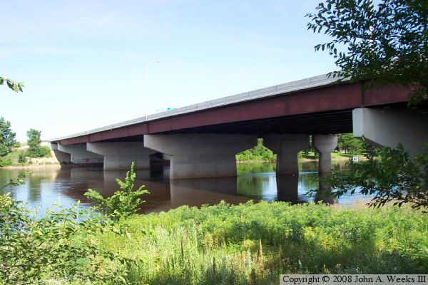
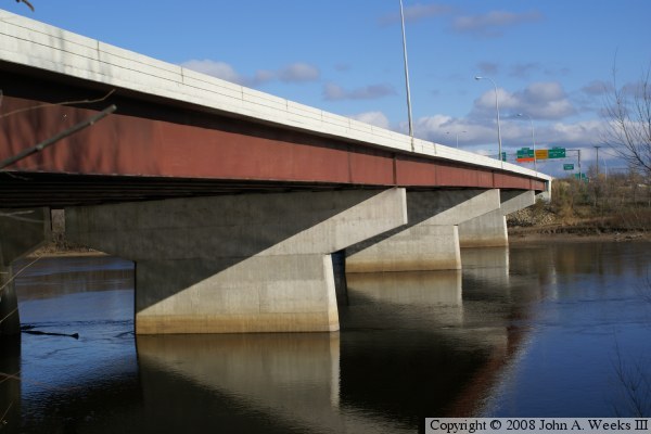
These various projects have resulted in an unusual arrangement of piers under the bridge. The original MN-100 bridge was located where the wide set of pier are now positioned. That bridge was removed and replaced by this new eastbound span. The original 1945 MN-100 span was the same width as the 1963 westbound span, which is the middle set of piers. When the westbound span was rebuilt wider in 1988, the set of small piers were built to carry the additional lanes. As a result, we have two spans with three sets of piers, with each set of piers being a different width.

The photo above was taken from River Ridge Park on the southeast corner of the bridges. This view shows the different sized piers. The photo 
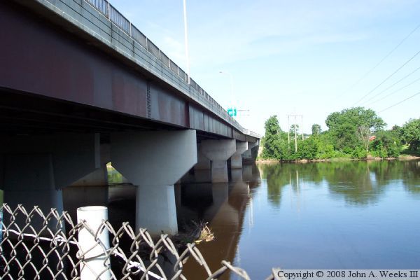
below was taken from under the east side of the westbound span.


I-694 Bridge
I-694 Bridge
The photo above is a view from the water level as seen from the boat landing located just south of the I-694 bridge. This boat landing can be reached from an access road located at the 57th Avenue N overpass over I-94.

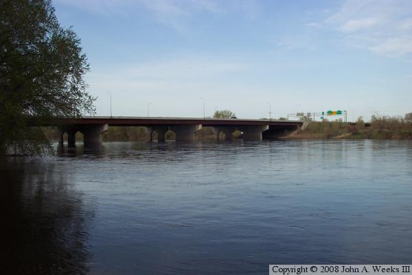
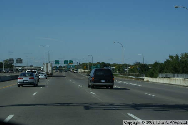
The photo below is the first of 3 photos showing a typical river crossing heading westbound. The first photo is heading towards the bridge in the center lane of westbound I-694.


I-694 Bridge
I-694 Bridge
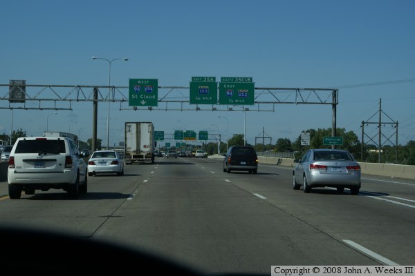
The photo above is the second of three photos showing a Mississippi River crossing via the I-694 bridge. We continue westbound, and are about halfway across the bridge. Overhead signs inform drivers of a number of options coming up just past the end of the bridge. The photo below is the very end of the westbound river crossing. We notice that there is an exit ramp on the right that starts before the bridge ends. This is the ramp to northbound MN-252, which carries traffic up to the MN-610 freeway.

I-694 Bridge
I-694 Bridge
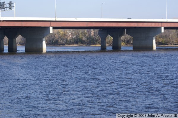
These two photos are a view from a bright sunny warm day in November of 2008. The upper photo was taken from the fishing pier at the North Mississippi Regional Park. The photo above is a profile shot, while the photo below is a close view of the main channel.

I-694 Bridge
I-694 Bridge
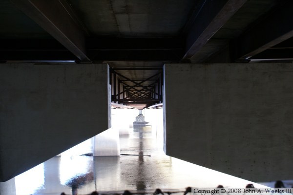
The photo above is the west bridge abutment. A regional trail crosses under the bridge at this location. The photo below is a detail of the metalwork under the bridge showing how the two spans are tied together.

I-694 Bridge
I-694 Bridge
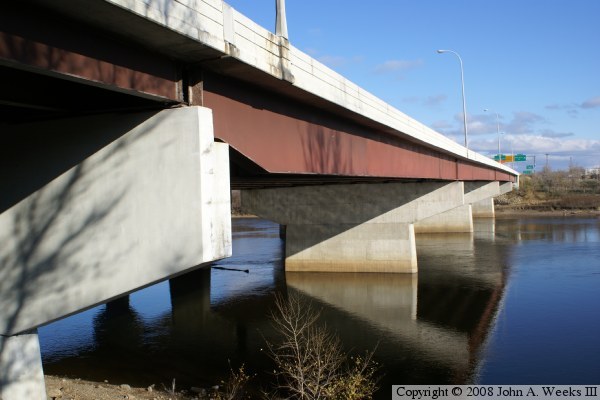
These two photos were taken from river level on the downriver side of the west end of the bridge. This area is accessible from the North Mississippi Park, which is situated between I-94 and the Mississippi River on the north side of Minneapolis. In the photo above, notice that the steel girder supporting the westernmost span is much thinner than the girders on the remaining spans. This detail is not duplicated on the east end of the structure.

I-694 Bridge

Made With Macintosh
Authored by John A. Weeks III, Copyright © 1996—2016, all rights reserved.
For further information, contact: john@johnweeks.com