Current Weather Conditions
John A. Weeks III
Sunday, March 14, 2010, 12:37:54 AM CST
Home 12 Easy Steps Random Topics About The Author Portal
Aviation Spacecraft Highways & Bridges Photo Tours Rail Fan

Google Search

 Maps  Groups
 Images  Search
  Home
  • 12 Easy Steps
  • Aviation
  • Spacecraft
  • Highways & Bridges
    » Bridge Photography
      - MSP River Bridges
        › 10th Avenue Bridge
        › Arcola High Bridge
        › Betty Adkins Bridge
        › Bloomington Ferry
        › Bloomington Fry Tr
        › BNSF RR Bridge
        › Boom Island Foot Br
        › Broadway Avenue Br
        › C & NW Bridge (1)
        › C & NW Bridge (2)
        › Camden Bridge
        › Cedar Avenue Bridge
        › Cedar Ave Br (Old)
        › Cedar Ave Bicycle Br
        › Cedar Bend RR Br
        › Chaska Bridge (Old)
        › Coon Rapids Dam
        › CP RR Bridge
        › Dan Patch Line Br
        › Dartmouth Bridge
        › East Channel Bridge
        › East Channel RR Br
        › East River Flats Br
        › F. W. Cappelen Mem
        › Father Henn Bluffs
        › Father Louis Henn Br
        › Ferry Street Bridge
        › First Avenue Bridge
        › Fort Road Bridge
        › Fort Snelling Br (Old)
        › Fort Snelling Br (Foot)
        › Fort Snelling High Br
        › Great Western Bridge
        › Grey Cloud Channel
        › Grey Cloud Island Br
        › Grey Cloud Trail Br
        › H&D RR Bridge
        › H&D RR Trestle
        › Hastings High Bridge
        › Hastings Spiral Br
        › Holmes St Ped Bridge
        › Highway 243 Bridge
        › I-35W Bridge
        › I-35W Bridge (Old)
        › I-494 Bridge
        › I-694 Bridge
        › Interstate Bridge
        › Intercity Bridge
        › L St. Anthony F L&D
        › Lafayette Bridge
        › Lake Street Bridge
        › Lexington Bridge
        › Lions Levee Pk Foot
        › Lock & Dam #1
        › Lock & Dam #2
        › Long Meadow Bridge
        › Lower Bridge
        › Lowry Bridge (Old)
        › Meeker Island L&D
        › Mendota Bridge
        › Merriam Street Br
        › Mill Ruins Park Br
        › Milwaukee Road Br
        › M&SL RR Bridge
        › Miss River Bridge 15
        › MN-101 Bridge
        › MN-41 Backchannel
        › MN-41 Back Ch (Old)
        › MN-41 Bridge
        › New Saint Croix Br
        › New Trunk-41 Bridge
        › Nicollet Island RR Br
        › North Miss Park Pier
        › NP Bridge #9
        › NP RR Bridge
        › Plymouth Bridge
        › Point Douglas DB
        › Raspberry Island Br
        › Richard P. Braun Br
        › Robert Street
        › Rock Island Bridge
        › Runway 30 Light Br
        › Shakopee Bridge
        › Short Line Bridge
        › Smith Avenue High
        › Southeast Steam Plant
        › St. Anthony Falls Br
        › St. Anthony Falls Lab
        › St. Anthony Falls PP
        › St. Croix Boom Site
        › St. Croix Falls Dam
        › Stillwater Lift Br
        › Stone Arch Bridge
        › Third Avenue Bridge
        › Toll Bridge (Old)
        › U St. Anthony F L&D
        › US-8 Bridge
        › Wabasha Street Bridge
        › Wakota Bridge
        › Wakota Bridge (Old)
        › Walnut Street CW
        › Washington Ave Br
        › WI Central RR Br
        › WI Central RR Ruins
        › Wright Co Hwy 42
      - Illinois River
      - Minnesota River
      - Mississippi River
      - Missouri River
      - St. Croix River
      - St. Louis River
      - Wisconsin River
      - Cable Stayed Bridges
      - McGilvray Road
      - I-35W Bridge Disaster
      - Miscellaneous Bridges
    » Road Geek Topics
  • Random Topics
  • Photo Tours
  • Rail Fan
  • About The Author
  • John's Portal
 
Site Search By JRank
Highways, Byways, And Bridge Photography
First Avenue Bridge
First Avenue Mississippi River Crossing
Minneapolis, MN

First Avenue Bridge

• Structure ID: NBI: 27537.
• Location: River Mile 854.4.
• River Elevation: 801 Feet.
• Highway: CSAH-52 (Southbound), First Avenue.
• Daily Traffic Count: 9,850 (2001).
• Bridge Type: Steel Girder.
• Length: 414 Feet.
• Width: 40 Feet, 3 Lanes.
• Navigation Channel Width: Non-Navigable.
• Height Above Water: 27 Feet.
• Date Built: 1971.
There are two river channels in the Saint Anthony Falls area. The main channel of the Mississippi River runs along the west bank of the river. The east channel of the Mississippi River runs along the east bank of the river. The two channels are separated by Nicollet Island.

The Hennepin Avenue river crossing consists of three bridges. This includes suspension bridge over the main channel, and a pair of one-way steel girder bridges over the east channel. This page discusses the southbound bridge over the east channel, also known as the First Avenue Bridge.

The First Avenue Bridge is a very generic modern steel girder bridge with a concrete deck. It does have sidewalks that are protected from traffic by smaller guardrails and curbs. Beyond that, it has no decorative features. The bridge was painted in 1990 to match the green color of the Father Louis Hennepin Bridge.

Southbound traffic previously used the old East Channel Bridge, which was a 5 span stone arch bridge. That bridge was removed in 1973 after this bridge was completed.

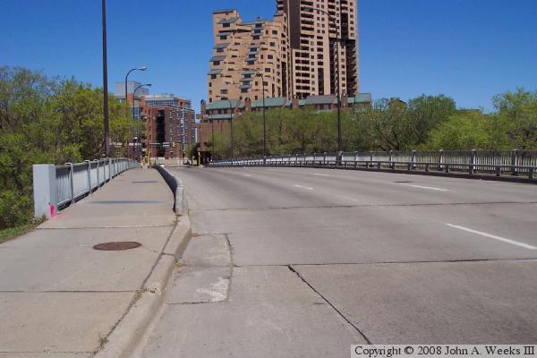
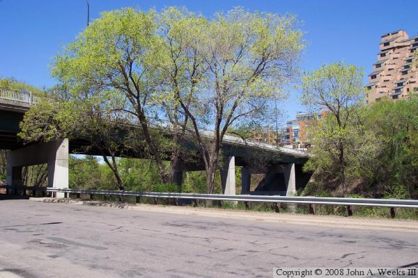
The photo above is a side view of the bridge taken from Island Avenue, the road that circles Nicollet Island. The photo below is a view of the First Avenue Bridge taken from street level. This view is looking north towards the Riverplace condominium project.


First Avenue Bridge

Made With Macintosh
Authored by John A. Weeks III, Copyright © 1996—2010, all rights reserved.
For further information, contact: john@johnweeks.com