Current Weather Conditions
John A. Weeks III
Friday, April 19, 2024, 3:28:58 AM CDT
Home Photo Tours Rail Fan 12 Easy Steps
Aviation Spacecraft Highways & Bridges About The Author
 
Google Search
Maps   Groups   Images   Search
 
  Home
  • 12 Easy Steps
  • Aviation
  • Spacecraft
  • Highways & Bridges
    » Bridge Photography
      - MSP River Bridges
        › 10th Avenue Bridge
        › Arcola High Bridge
        › Betty Adkins Bridge
        › Bloomington Ferry
        › Bloomington Fry Tr
        › BNSF RR Bridge
        › Boom Island Foot Br
        › Broadway Avenue Br
        › C&NW Bridge (1)
        › C&NW Bridge (2)
        › Camden Bridge
        › Cedar Avenue Bridge
        › Cedar Ave Br (Old)
        › Cedar Ave Bicycle Br
        › Cedar Bend RR Br
        › Chaska Bridge (Old)
        › Chaska Swing Bridge
        › Chaska Trestle
        › Coon Rapids Dam
        › CP RR Bridge
        › Dan Patch Line Br
        › Dartmouth Bridge
        › East Channel Bridge
        › East Channel RR Br
        › East River Flats Br
        › Endless Bridge
        › F. W. Cappelen Mem
        › Father Henn Bluffs
        › Father Louis Henn Br
        › Ferry Street Bridge
        › First Avenue Bridge
        › Fort Road Bridge
        › Fort Snelling Br (Old)
        › Fort Snelling High Br
        › Great Western Bridge
        › Grey Cloud Channel
        › Grey Cloud Island Br
        › Grey Cloud Trail Br
        › Hastings High Bridge
        › Hastings Spiral Br
        › Holmes St Ped Bridge
        › Highway 243 Bridge
        › I-35W Bridge
        › I-35W Bridge (Old)
        › I-494 Bridge
        › I-694 Bridge
        › Interstate Bridge
        › Intercity Bridge
        › L St. Anthony F L&D
        › Lafayette Bridge
        › Lake Street Bridge
        › Lewis Street Bridge
        › Lexington Bridge
        › Lions Levee Pk Foot
        › Lock & Dam #1
        › Lock & Dam #2
        › Long Meadow Bridge
        › Lower Bridge
        › Lowry Bridge (Old)
        › Meeker Island L&D
        › Mendota Bridge
        › Merriam Street Br
        › Mill Ruins Park Br
        › Milwaukee Road Br
        › M&StL Bridge
        › Miss River Bridge 15
        › MN-101 Bridge
        › MN-41 Backchannel
        › MN-41 Back Ch (Old)
        › MN-41 Bridge
        › New Saint Croix Br
        › New Trunk-41 Bridge
        › Nicollet Island RR Br
        › North Miss Park Pier
        › NP Bridge #9
        › NP RR Bridge
        › Pike Island Bridge
        › Plymouth Bridge
        › Point Douglas DB
        › Raspberry Island Br
        › Richard P. Braun Br
        › Robert Street
        › Rock Island Swing Br
        › Runway 30 Light Br
        › Short Line Bridge
        › Smith Avenue High
        › Southeast Steam Plant
        › St. Anthony Falls Br
        › St. Anthony Falls Lab
        › St. Anthony Falls PP
        › St. Croix Boom Site
        › St. Croix Falls Dam
        › Stillwater Lift Br
        › Stone Arch Bridge
        › Third Avenue Bridge
        › Toll Bridge (Old)
        › U St. Anthony F L&D
        › US-8 Bridge
        › Wabasha Street Bridge
        › Wakota Bridge
        › Wakota Bridge (Old)
        › Walnut Street CW
        › Washington Ave Br
        › WI Central RR Br
        › WI Central RR Ruins
        › Wright Co Hwy 42
      - C & D Canal
      - Illinois River
      - Minnehaha Creek
      - Minnesota River
      - Mississippi River
      - Missouri River
      - St. Croix River
      - St. Louis River
      - Wisconsin River
      - Best Miss River Photos
      - Cable Stayed Bridges
      - McGilvray Road Bridges
      - I-35W Bridge Disaster
      - Miscellaneous Bridges
      - Madison County Bridges
      - Hist Br Weekend 2013
    » Road Geek Topics
  • Photo Tours
  • Rail Fan
  • About The Author
 
Site Search By JRank
Highways, Byways, And Bridge Photography
Chaska Swing Bridge
Former H & D Railroad Minnesota River Crossing
Chaska, MN

Chaska Swing Bridge

• Structure ID: N/A.
• Location: River Mile 30.8.
• River Elevation: 695 Feet.
• Railroad: Hastings & Dakota, Milwaukee Road.
• Daily Traffic Count: 0, Bridge Has Been Removed.
• Bridge Type: Steel Through Truss w/Swing Span.
• Length: 380 Feet (Estimated).
• Width: 1 Track.
• Navigation Channel Width: Non-Navigable.
• Height Above Water: ???.
• Date Built: 1900, Using 1871 Abutments.
The year 1871 was an exciting time for the Minnesota River Valley. The railroads were coming. The transcontinental railroad opened in 1869, and the race was on to get across the state of Minnesota and over to Omaha. The Winona & Saint Peter, which later became the Omaha Road, was building a swing bridge at Saint Peter. The Minneapolis & Saint Louis was building a bridge at Carver. And the Hastings & Dakota was heading westward from Hastings by building a swing bridge at Chaska.

The Hastings & Dakota already had a line between Minneapolis and Saint Paul. They desired a line around the city to bypass the congestion of the maze of tracks in Minneapolis. The route that they selected ran through Farmington, Prior Lake, Shakopee, and down the south side of the river to Chaska. The route crossed at Chaska on a swing bridge, followed the riverbank for about a mile, then crossed a trestle into the city of Chaska. The line continued west to Cologne.

The original 1871 bridge was an iron swing bridge. It featured the center pin design where the movable bridge section was one single truss span. These bridges were notoriously difficult to keep balanced. The truss sat on a group of rollers that followed a circular track mounted to the top of the center bridge pier. When the bridge needed to be opened, as many as four men would walk to the center of the bridge, and insert bars through the tracks to push on the center pier, causing the bridge to swing open.

The Hastings & Dakota was taken over by the Milwaukee Road shortly after this line opened. The Milwaukee Road pushed west across the state and into South Dakota. In 1905, the Milwaukee Road started building west from Mobridge, South Dakota, and completed their Pacific route to Seattle. Despite having the best route to the Pacific and dominating traffic coming out of Seattle, the Milwaukee Road mismanaged the route and ended up in bankruptcy.

The original iron bridge was obsolete and was replaced in 1900, with the rebuilt rail line opening again in early 1901. A new concrete abutment was built at the north end of the bridge, a Pratt through truss span was installed on the north side of the river, and a pair of Pratt truss spans were joined together to form the swing span. This swing span was also manually operated. The bridge tender would walk to the center of the bridge, insert a crank through the track, and turn a gear on a mechanism located under the track.

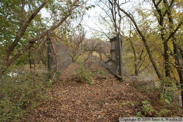
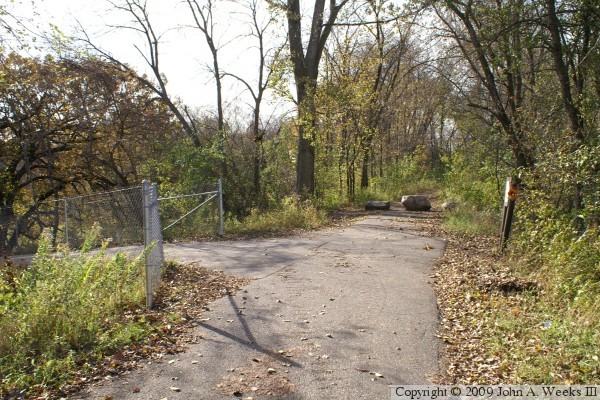
The Milwaukee Road built a connector from Hopkins on the west side of Minneapolis to Cologne, which resulted in the Chaska bridge becoming a secondary route. Traffic dropped off after World War II, and the route through Chaska was abandoned in 1972 after an locomotive derailment damaged a highway bridge over Carver County highway 40. Shortly after the abandonment, the concept of rails to trails was born. The state DNR and the counties of Carver and Scott teamed up to build one of the first rails to trails project in the state. They reclaimed the old Hasting & Dakota line between Chaska and Shakopee and converted it into a paved bicycle and walking path in 1980. Both the bridge and the nearby trestle were redecked and railings were installed. The four mile long path proved to be very successful and helped to prove the concept of rails to trails. The highlight of the trail was the Minnesota River crossing on the old swing bridge.

The swing bridge experienced a problem in 1991. It was noticed that the north bridge abutment had shifted 2 inches out of alignment. The abutment was repaired, and the trail was reopened. Then disaster struck the Chaska-Shakopee Bicycle Trail in the late summer of 1996. On August 18, it was noticed that the swing span center pier was leaning. The bridge was closed on August 20, but nearly 300 people climbed the fences and crossed the bridge that day. On August 21, another pier was observed to be leaning. The state DNR inspected the center pier, and found that it was crumbling due to a scour hole that had developed on the upstream side of the pier. This was possibly triggered by a large ice jam that had developed in the river earlier in the year. The DNR determined that the bridge could not be saved, so they engaged a demolition company to bring the bridge down. The Chaska Herald reported that the bridge was leaning 10 degrees towards the west on August 22. Crews worked to attach explosives to the structure on the morning of August 23, and the bridge was blown at 2:25 PM.

At this point, the story gets even worse. Local officials and state representatives were working to obtain funding for a new trail bridge across the Minnesota River at the site of the Chaska Swing Bridge. However, those plans went up in smoke on Halloween night, 1996, when a group of youth accidentally set the Chaska Trestle on fire. By the time the fire was reported and fire crews arrived on scene, the south end of the trestle was almost fully consumed. Fire crews were able to keep the fire off of the northern third of the bridge, but the southern third was damaged beyond repair.

The Chaska-Shakopee Bicycle Trail languished for over a decade. An extension was built south of the river from the old bridge to a landing near MN-41, but there was no way to bring the trail into Chaska. The MN-41 river bridge was too narrow and too busy to allow hikers or bicycle traffic. Finally, a new highway bridge was started in 2004. When finished, it would feature wide sidewalks on each side of the traffic lanes to accommodate regional trail traffic. The new bridge opened in 2007. Once again, this gem of a trail is back in full operation.

Credit goes to railfan and bridge hunter John Marvig for doing much of the research that made this page possible. John located newspaper stories, original photos, and even spoke with people who had photographed the bridge prior to its demise. You can check out these photos on John’s page on the Chaska Swing Bridge.

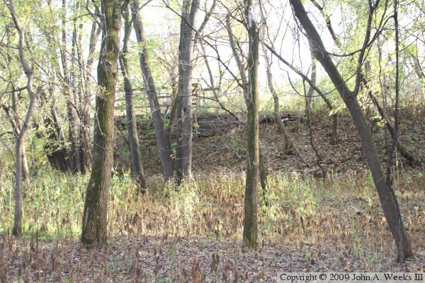
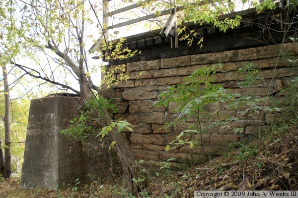
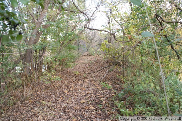
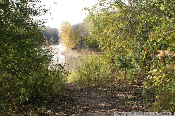
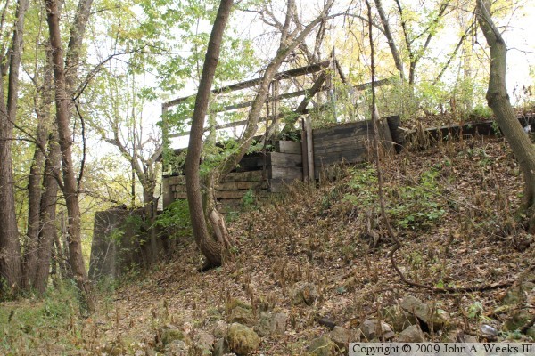
The photo above is looking west towards the remains of the north bridge abutment. The swing span rested on the shorter concrete pier when the bridge was in the closed position. The photo below is a view of the railroad embankment looking through the forest from a nearby access road. The Minnesota river is on the far side of the embankment.


Chaska Swing Bridge
Chaska Swing Bridge
The photo above is the bridge abutment as seen from the edge of the river. It is well hidden by trees that have grown since the bridge was removed. The photo below is looking south across the river where the south bridge abutment once stood. While I did not see it when I visited the north side of the river, part of the south bridge abutment still exists and is visible in this photo.

Chaska Swing Bridge
Chaska Swing Bridge
These two photos are close views of the east face of the north bridge abutment. The west side of the abutment is too close to the river to safely photograph.

Chaska Swing Bridge
Chaska Swing Bridge
These two photos are looking south from the top of the railroad embankment. The railroad railbed was converted to a regional trail and paved with an 8 foot wide strip of blacktop. The bridge deck was covered with a wooden floor and railings were installed. The photo above is a view of the remaining section of bridge deck. The photo below is looking beyond the bridge deck and across the Minnesota River.

Chaska Swing Bridge
Chaska Swing Bridge
The photo above is a view looking south along the trail that follows the railroad embankment. The trail is still in very good condition despite being abandoned for over 20 years. It is covered with a thin layer of mud and decomposed leaves. The photo below is a section of the trail where the railroad embankment collapsed after a recent flood. Trees that once stood along the edge of the river have fallen across the trail making it impassible.

Chaska Swing Bridge
Chaska Swing Bridge
The photo above is the Chaska and Shakopee Trail near the south end of the former river crossing. The trail heads north towards the old bridge. The branch to the west heads towards the new river crossing at the MN-41 highway bridge. The photo below is the end of the old section of trail as it approaches the bridge site.

Chaska Swing Bridge
Chaska Swing Bridge
The photo above is the end of the trail on the south side of the Minnesota River. There is a path that continues down to the riverbank. The photo below is looking across the river towards the bridge abutment on the north side of the Minnesota River. The river bends to the north and parallels the railroad embankment for nearly a mile when traveling upstream.

Chaska Swing Bridge
Chaska Swing Bridge
These two photo are the remains of the bridge abutment on the south side of the river channel. The photo above is a view of the remains from near the riverbank. The photo below is the remains as seen from the trail at the top of the railroad embankment.

Chaska Swing Bridge

Made With Macintosh
Authored by John A. Weeks III, Copyright © 1996—2016, all rights reserved.
For further information, contact: john@johnweeks.com