Current Weather Conditions
John A. Weeks III
Saturday, July 27, 2024, 8:14:50 AM CDT
Home Photo Tours Rail Fan 12 Easy Steps
Aviation Spacecraft Highways & Bridges About The Author
 
Google Search
Maps   Groups   Images   Search
 
  Home
  • 12 Easy Steps
  • Aviation
  • Spacecraft
  • Highways & Bridges
    » Bridge Photography
      - MSP River Bridges
        › 10th Avenue Bridge
        › Arcola High Bridge
        › Betty Adkins Bridge
        › Bloomington Ferry
        › Bloomington Fry Tr
        › BNSF RR Bridge
        › Boom Island Foot Br
        › Broadway Avenue Br
        › C&NW Bridge (1)
        › C&NW Bridge (2)
        › Camden Bridge
        › Cedar Avenue Bridge
        › Cedar Ave Br (Old)
        › Cedar Ave Bicycle Br
        › Cedar Bend RR Br
        › Chaska Bridge (Old)
        › Chaska Swing Bridge
        › Chaska Trestle
        › Coon Rapids Dam
        › CP RR Bridge
        › Dan Patch Line Br
        › Dartmouth Bridge
        › East Channel Bridge
        › East Channel RR Br
        › East River Flats Br
        › Endless Bridge
        › F. W. Cappelen Mem
        › Father Henn Bluffs
        › Father Louis Henn Br
        › Ferry Street Bridge
        › First Avenue Bridge
        › Fort Road Bridge
        › Fort Snelling Br (Old)
        › Fort Snelling High Br
        › Great Western Bridge
        › Grey Cloud Channel
        › Grey Cloud Island Br
        › Grey Cloud Trail Br
        › Hastings High Bridge
        › Hastings Spiral Br
        › Holmes St Ped Bridge
        › Highway 243 Bridge
        › I-35W Bridge
        › I-35W Bridge (Old)
        › I-494 Bridge
        › I-694 Bridge
        › Interstate Bridge
        › Intercity Bridge
        › L St. Anthony F L&D
        › Lafayette Bridge
        › Lake Street Bridge
        › Lewis Street Bridge
        › Lexington Bridge
        › Lions Levee Pk Foot
        › Lock & Dam #1
        › Lock & Dam #2
        › Long Meadow Bridge
        › Lower Bridge
        › Lowry Bridge (Old)
        › Meeker Island L&D
        › Mendota Bridge
        › Merriam Street Br
        › Mill Ruins Park Br
        › Milwaukee Road Br
        › M&StL Bridge
        › Miss River Bridge 15
        › MN-101 Bridge
        › MN-41 Backchannel
        › MN-41 Back Ch (Old)
        › MN-41 Bridge
        › New Saint Croix Br
        › New Trunk-41 Bridge
        › Nicollet Island RR Br
        › North Miss Park Pier
        › NP Bridge #9
        › NP RR Bridge
        › Pike Island Bridge
        › Plymouth Bridge
        › Point Douglas DB
        › Raspberry Island Br
        › Richard P. Braun Br
        › Robert Street
        › Rock Island Swing Br
        › Runway 30 Light Br
        › Short Line Bridge
        › Smith Avenue High
        › Southeast Steam Plant
        › St. Anthony Falls Br
        › St. Anthony Falls Lab
        › St. Anthony Falls PP
        › St. Croix Boom Site
        › St. Croix Falls Dam
        › Stillwater Lift Br
        › Stone Arch Bridge
        › Third Avenue Bridge
        › Toll Bridge (Old)
        › U St. Anthony F L&D
        › US-8 Bridge
        › Wabasha Street Bridge
        › Wakota Bridge
        › Wakota Bridge (Old)
        › Walnut Street CW
        › Washington Ave Br
        › WI Central RR Br
        › WI Central RR Ruins
        › Wright Co Hwy 42
      - C & D Canal
      - Illinois River
      - Minnehaha Creek
      - Minnesota River
      - Mississippi River
      - Missouri River
      - St. Croix River
      - St. Louis River
      - Wisconsin River
      - Best Miss River Photos
      - Cable Stayed Bridges
      - McGilvray Road Bridges
      - I-35W Bridge Disaster
      - Miscellaneous Bridges
      - Madison County Bridges
      - Hist Br Weekend 2013
    » Road Geek Topics
  • Photo Tours
  • Rail Fan
  • About The Author
 
Site Search By JRank
Highways, Byways, And Bridge Photography
East Channel Railroad Bridge
BNSF Railroad Mississippi River Crossing
Minneapolis, MN

East Channel Railroad Bridge

• Structure ID: N/A.
• Location: River Mile 854.5.
• River Elevation: 801 Feet.
• Railroad: Burlington Northern Santa Fe Railroad.
• Daily Traffic Count: 12 Trains Per Day (Estimated).
• Bridge Type: Steel Plate Deck (Old), Concrete Girder (New).
• Length: 227 Feet, 67 Foot Longest Span.
• Width: Two Tracks.
• Navigation Channel Width: Non-Navigable.
• Height Above Water: 14 Feet.
• Date Built: Opened 1926.
The Saint Paul and Pacific Railroad built the first bridge across the Mississippi River in the Twin Cities area at this location. The bridge opened May 1, 1867. The complete river crossings consists of two spans, one over the main channel of the Mississippi River, and this bridge over the smaller east channel of the Mississippi River. The land between the two river channels is known as Nicollet Island.

The first bridge was an iron truss bridge, with the trains running through the truss span. In 1901, the Wisconsin Central built a curved spur bridge off of the main bridge. This allowed Wisconsin Central trains to cross on to Nicollet Island, travel along the north edge of the island, then cross another bridge to their rail yard on Boom Island.

The East Channel Railroad bridge was rebuilt in 1926. A new deck girder bridge was built on top of the original piers. That bridge has been in place largely unchanged until 2008. In the summer of 2008, the southern of the two spans parallel spans was removed and replaced with a precast concrete railroad bridge. This bridge sits on the original 1867 piers. The second parallel span will be replaced early in 2009.

This bridge has gone through a number of owners since 1867. This includes the Saint Paul & Pacific, the Saint Paul, Minneapolis and Manitoba Railway, and later the Great Northern Railway. The Great Northern was part of a large merger to become the Burlington Northern, which merged once again to become the Burlington Northern Santa Fe. In addition to being used by a major railroad, several other railroads have trackage rights to this bridge. As a result, one does not need to wait long to see a train cross this structure.

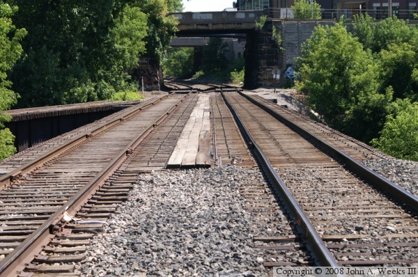
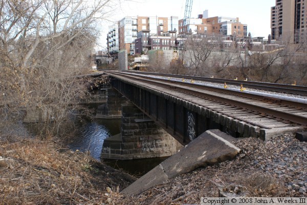
The photo at the top is a 2006 vintage photo of the bridge. This photo was taken prior to the current construction work on the bridge. It shows the bridge in its same configuration that it has been since 1926. The three boards running the length of the bridge in the middle are to fill the gap between the two parallel bridge spans.


East Channel Railroad Bridge
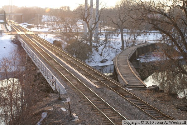
The photo above is a view of the East Channel Railroad Bridge as seen from a highway overpass located on Nicollet Island. An older timber span is on the left, while the new concrete span is on the right. The old Wisconsin Central branch curves off to the far left of the photo.

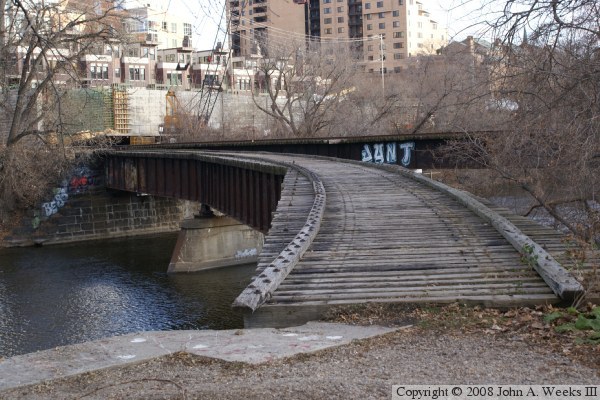
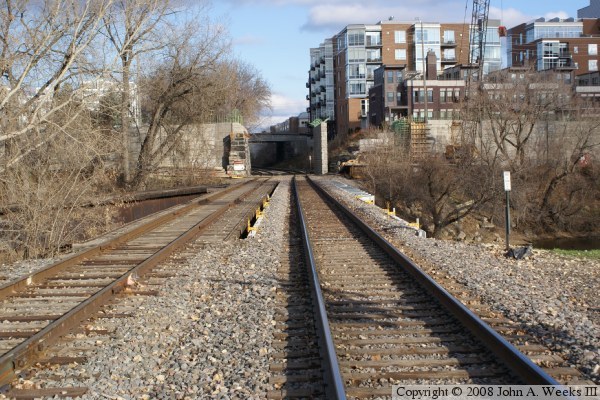
The photo below is a ground level view of the Wisconsin Central spur that curves off of the main bridge. The curve was built using a series of straight bridge sections. Notice that this span is more or less level, while the two parallel spans in the background are climbing towards the right side of the photo. The mainline needs to climb almost 10 feet as it crosses Nicollet Island to meet the elevation of the main channel bridge.


East Channel Railroad Bridge
These two photos are side views of the Wisconsin Central branch off of the East Channel Railroad Bridge. These views give us a chance to look at the bridge piers, which are of 1901 vintage. The photo above is the upriver view, while the photo below is the downriver view.

East Channel Railroad Bridge
These two photos are looking to the southwest from the overpass on Main Street. The photo below shows the old Wisconsin Central line branching off of the main line on the curved bridge. The photo below is looking into the setting sun as it is reflecting off of the shiny surface of the rails.

East Channel Railroad Bridge
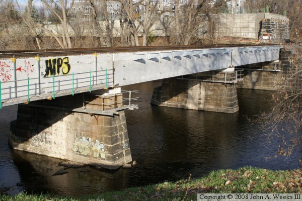
These two photos are views of the two parallel bridge spans over the East Channel of the Mississippi River. The bridge span on the left is the 1926 steel deck plate girder bridge. The bridge span on the right is the 2008 precast concrete bridge. Notice the shine on the railroad tracks on the right side, which indicates that heavy traffic is using the new span despite it not being fully completed.

East Channel Railroad Bridge
These two photos show the new span for the downriver of the two parallel tracks. The old bridge was removed, new bearing blocks were installed on top of the piers, and precast bridge segments were placed with a crane. Notice that the Main Street bridge over the railroad tracks in the background is being rebuilt. The bridge design has incorporated the old bridge piers into the abutments.

East Channel Railroad Bridge
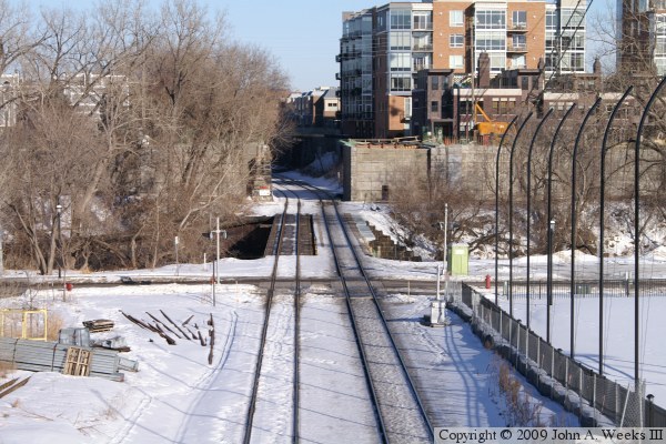
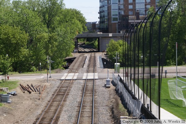
The photo above is a summer view from the Nicollet Street overpass located on Nicollet Island. The view is looking northeast towards the only Main Street area.

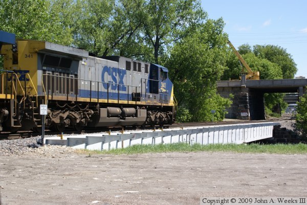
The photo below is a CSX locomotive entering the bridge headed northbound across the Mississippi River. I have no clue what a CSX train is doing in Minnesota. CSX does have some track rights agreements with the BNSF, but this is more likely the case where the BNSF is leasing CSX locomotives.


East Channel Railroad Bridge
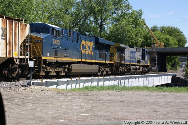
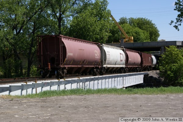
In the photo above, the CSX train is continuing its northbound journey across the Mississippi River. The photo below shows the tail end of the train crossing the East Channel Railroad Bridge.

East Channel Railroad Bridge

Made With Macintosh
Authored by John A. Weeks III, Copyright © 1996—2016, all rights reserved.
For further information, contact: john@johnweeks.com