Current Weather Conditions
John A. Weeks III
Sunday, February 9, 2025, 9:02:55 PM CST
Home Photo Tours Rail Fan 12 Easy Steps
Aviation Spacecraft Highways & Bridges About The Author
 
Google Search
Maps   Groups   Images   Search
 
  Home
  • 12 Easy Steps
  • Aviation
  • Spacecraft
  • Highways & Bridges
    » Bridge Photography
      - MSP River Bridges
        › 10th Avenue Bridge
        › Arcola High Bridge
        › Betty Adkins Bridge
        › Bloomington Ferry
        › Bloomington Fry Tr
        › BNSF RR Bridge
        › Boom Island Foot Br
        › Broadway Avenue Br
        › C&NW Bridge (1)
        › C&NW Bridge (2)
        › Camden Bridge
        › Cedar Avenue Bridge
        › Cedar Ave Br (Old)
        › Cedar Ave Bicycle Br
        › Cedar Bend RR Br
        › Chaska Bridge (Old)
        › Chaska Swing Bridge
        › Chaska Trestle
        › Coon Rapids Dam
        › CP RR Bridge
        › Dan Patch Line Br
        › Dartmouth Bridge
        › East Channel Bridge
        › East Channel RR Br
        › East River Flats Br
        › Endless Bridge
        › F. W. Cappelen Mem
        › Father Henn Bluffs
        › Father Louis Henn Br
        › Ferry Street Bridge
        › First Avenue Bridge
        › Fort Road Bridge
        › Fort Snelling Br (Old)
        › Fort Snelling High Br
        › Great Western Bridge
        › Grey Cloud Channel
        › Grey Cloud Island Br
        › Grey Cloud Trail Br
        › Hastings High Bridge
        › Hastings Spiral Br
        › Holmes St Ped Bridge
        › Highway 243 Bridge
        › I-35W Bridge
        › I-35W Bridge (Old)
        › I-494 Bridge
        › I-694 Bridge
        › Interstate Bridge
        › Intercity Bridge
        › L St. Anthony F L&D
        › Lafayette Bridge
        › Lake Street Bridge
        › Lewis Street Bridge
        › Lexington Bridge
        › Lions Levee Pk Foot
        › Lock & Dam #1
        › Lock & Dam #2
        › Long Meadow Bridge
        › Lower Bridge
        › Lowry Bridge (Old)
        › Meeker Island L&D
        › Mendota Bridge
        › Merriam Street Br
        › Mill Ruins Park Br
        › Milwaukee Road Br
        › M&StL Bridge
        › Miss River Bridge 15
        › MN-101 Bridge
        › MN-41 Backchannel
        › MN-41 Back Ch (Old)
        › MN-41 Bridge
        › New Saint Croix Br
        › New Trunk-41 Bridge
        › Nicollet Island RR Br
        › North Miss Park Pier
        › NP Bridge #9
        › NP RR Bridge
        › Pike Island Bridge
        › Plymouth Bridge
        › Point Douglas DB
        › Raspberry Island Br
        › Richard P. Braun Br
        › Robert Street
        › Rock Island Swing Br
        › Runway 30 Light Br
        › Short Line Bridge
        › Smith Avenue High
        › Southeast Steam Plant
        › St. Anthony Falls Br
        › St. Anthony Falls Lab
        › St. Anthony Falls PP
        › St. Croix Boom Site
        › St. Croix Falls Dam
        › Stillwater Lift Br
        › Stone Arch Bridge
        › Third Avenue Bridge
        › Toll Bridge (Old)
        › U St. Anthony F L&D
        › US-8 Bridge
        › Wabasha Street Bridge
        › Wakota Bridge
        › Wakota Bridge (Old)
        › Walnut Street CW
        › Washington Ave Br
        › WI Central RR Br
        › WI Central RR Ruins
        › Wright Co Hwy 42
      - C & D Canal
      - Illinois River
      - Minnehaha Creek
      - Minnesota River
      - Mississippi River
      - Missouri River
      - St. Croix River
      - St. Louis River
      - Wisconsin River
      - Best Miss River Photos
      - Cable Stayed Bridges
      - McGilvray Road Bridges
      - I-35W Bridge Disaster
      - Miscellaneous Bridges
      - Madison County Bridges
      - Hist Br Weekend 2013
    » Road Geek Topics
  • Photo Tours
  • Rail Fan
  • About The Author
 
Site Search By JRank
Highways, Byways, And Bridge Photography
Saint Anthony Falls Laboratory
Mississippi River Research Laboratory
Minneapolis, MN

Saint Anthony Falls Laboratory

• Structure: Saint Anthony Falls Laboratory.
• Location: River Mile 853.9.
• River Elevation: 801 Feet.
• Date Built: 1938.
The Saint Anthony Falls Laboratory was established in 1938 as the Saint Anthony Hydraulic Laboratory. Its unique location on Hennepin Island in the middle of the Mississippi River at the apex of Saint Anthony Falls allows the lab to use the hydraulic head of the falls to provide water flow for a wide array of experiments and simulations. The lab once focused on modeling rivers and dams. With the slowdown in dam building, the lab performs research into other physical earth sciences, and performs modeling and simulation of dam removals and river restoration projects. The lab is affiliated with the University of Minnesota, and supports projects including those that are funded by the National Science Foundation.

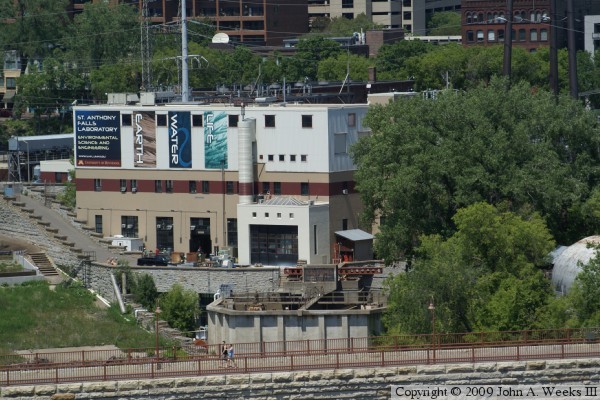
The photo above is a telephoto view of the laboratory building as seen from downtown Minneapolis. The facility sits on the downstream face of the Upper Saint Anthony Falls dam. An old spillway at the dam is used as an outdoor stream lab to model the dynamics of smaller rivers. The building has 2 floors above the river water level, and 3 floors located below the water level of the river.


Saint Anthony Falls Laboratory
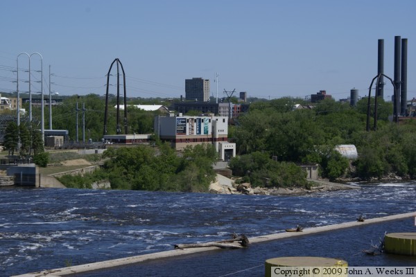
These two photos are views of the laboratory from the west bank of the Mississippi River. The photo above is a downstream view from the Endless Bridge at the Guthrie Theater. The photo below is an upstream view from an observation deck on the Third Avenue Bridge.

Saint Anthony Falls Laboratory

Made With Macintosh
Authored by John A. Weeks III, Copyright © 1996—2016, all rights reserved.
For further information, contact: john@johnweeks.com