Current Weather Conditions
John A. Weeks III
Tuesday, March 19, 2024, 6:40:25 AM CDT
Home Photo Tours Rail Fan 12 Easy Steps
Aviation Spacecraft Highways & Bridges About The Author
 
Google Search
Maps   Groups   Images   Search
 
  Home
  • 12 Easy Steps
  • Aviation
  • Spacecraft
  • Highways & Bridges
    » Bridge Photography
      - MSP River Bridges
        › 10th Avenue Bridge
        › Arcola High Bridge
        › Betty Adkins Bridge
        › Bloomington Ferry
        › Bloomington Fry Tr
        › BNSF RR Bridge
        › Boom Island Foot Br
        › Broadway Avenue Br
        › C&NW Bridge (1)
        › C&NW Bridge (2)
        › Camden Bridge
        › Cedar Avenue Bridge
        › Cedar Ave Br (Old)
        › Cedar Ave Bicycle Br
        › Cedar Bend RR Br
        › Chaska Bridge (Old)
        › Chaska Swing Bridge
        › Chaska Trestle
        › Coon Rapids Dam
        › CP RR Bridge
        › Dan Patch Line Br
        › Dartmouth Bridge
        › East Channel Bridge
        › East Channel RR Br
        › East River Flats Br
        › Endless Bridge
        › F. W. Cappelen Mem
        › Father Henn Bluffs
        › Father Louis Henn Br
        › Ferry Street Bridge
        › First Avenue Bridge
        › Fort Road Bridge
        › Fort Snelling Br (Old)
        › Fort Snelling High Br
        › Great Western Bridge
        › Grey Cloud Channel
        › Grey Cloud Island Br
        › Grey Cloud Trail Br
        › Hastings High Bridge
        › Hastings Spiral Br
        › Holmes St Ped Bridge
        › Highway 243 Bridge
        › I-35W Bridge
        › I-35W Bridge (Old)
        › I-494 Bridge
        › I-694 Bridge
        › Interstate Bridge
        › Intercity Bridge
        › L St. Anthony F L&D
        › Lafayette Bridge
        › Lake Street Bridge
        › Lewis Street Bridge
        › Lexington Bridge
        › Lions Levee Pk Foot
        › Lock & Dam #1
        › Lock & Dam #2
        › Long Meadow Bridge
        › Lower Bridge
        › Lowry Bridge (Old)
        › Meeker Island L&D
        › Mendota Bridge
        › Merriam Street Br
        › Mill Ruins Park Br
        › Milwaukee Road Br
        › M&StL Bridge
        › Miss River Bridge 15
        › MN-101 Bridge
        › MN-41 Backchannel
        › MN-41 Back Ch (Old)
        › MN-41 Bridge
        › New Saint Croix Br
        › New Trunk-41 Bridge
        › Nicollet Island RR Br
        › North Miss Park Pier
        › NP Bridge #9
        › NP RR Bridge
        › Pike Island Bridge
        › Plymouth Bridge
        › Point Douglas DB
        › Raspberry Island Br
        › Richard P. Braun Br
        › Robert Street
        › Rock Island Swing Br
        › Runway 30 Light Br
        › Short Line Bridge
        › Smith Avenue High
        › Southeast Steam Plant
        › St. Anthony Falls Br
        › St. Anthony Falls Lab
        › St. Anthony Falls PP
        › St. Croix Boom Site
        › St. Croix Falls Dam
        › Stillwater Lift Br
        › Stone Arch Bridge
        › Third Avenue Bridge
        › Toll Bridge (Old)
        › U St. Anthony F L&D
        › US-8 Bridge
        › Wabasha Street Bridge
        › Wakota Bridge
        › Wakota Bridge (Old)
        › Walnut Street CW
        › Washington Ave Br
        › WI Central RR Br
        › WI Central RR Ruins
        › Wright Co Hwy 42
      - C & D Canal
      - Illinois River
      - Minnehaha Creek
      - Minnesota River
      - Mississippi River
      - Missouri River
      - St. Croix River
      - St. Louis River
      - Wisconsin River
      - Best Miss River Photos
      - Cable Stayed Bridges
      - McGilvray Road Bridges
      - I-35W Bridge Disaster
      - Miscellaneous Bridges
      - Madison County Bridges
      - Hist Br Weekend 2013
    » Road Geek Topics
  • Photo Tours
  • Rail Fan
  • About The Author
 
Site Search By JRank
Highways, Byways, And Bridge Photography
Old Cedar Avenue Bridge
Historic Cedar Avenue Minnesota River Crossing
Bloomington, MN to Eagan, MN

Old Cedar Avenue Bridge

• Structure ID: N/A.
• Location: River Mile 7.3.
• River Elevation: 686 Feet.
• Highway: Former Cedar Avenue.
• Daily Traffic Count: 0 (Bridge Has Been Removed).
• Bridge Type: Steel Truss Swing Span.
• Length: ??? Feet.
• Width: ??? Feet, 2 Lanes.
• Navigation Channel Width: ??? Feet.
• Height Above Water: ???.
• Date Built: 1890.
The first Cedar Avenue Bridge was built in 1890, and it was in operation for 90 years until it was replaced by the current twin structures of the Highway 77 Cedar Avenue Bridges. The river crossing consisted of two spans. The first was the swing bridge over the main channel of the Minnesota River. The second was a wood trestle over the back channel waters of the Minnesota River Valley to the north of the main river channel. The trestle was replaced in 1920 with a 5 span steel through truss bridge. That bridge, known as the Long Meadow Bridge, still stands today.

The swing span structure was removed shortly after the new highway bridges were completed. No pieces of the swing span are known to have survived, and there are no structural elements or foundations existing where it was once located. The site of the bridge is, however, well defined by the roads that lead to the edge of the river on both sides of the main channel. This photo series documents this site as of the fall of 2009.

Many visitors to this page will be confused about which bridge is being discussed on this page. The Long Meadow Bridge is very commonly called the Old Cedar Avenue Bridge, and many folks are unaware of its name or history. Further, the Long Meadow Bridge has been a topic of discussion in the media throughout the first decade of the 2000s as the city of Bloomington has been trying to raise money to repair or replace it in order to reopen the bicycle trail river crossing. A page on the Long Meadow Bridge can be found at this link.

The photo above is the end of the road for Old Cedar Avenue. The north abutment for the swing bridge once stood just beyond the guardrail. I doubt that this is pavement from the time when the swing bridge was still in use. A historical society photo of the swing bridge suggests that the abutment was 15 or 20 feet above ground level. In addition, the pavement seems to be in too good of shape and does not show any evidence of a yellow center line, leading me to believe that this is an overlay from after the swing bridge was removed.


Old Cedar Avenue Bridge
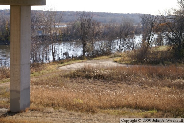
The photo above is the road leading to the north end of the Old Cedar Avenue Bridge. The bridge abutment was located just beyond the guard rail near the river bank. The photo below is looking north from this same location. This road once carried Cedar Avenue between the old swing bridge and the Long Meadow Bridge, located 2,000 feet to the north.

Old Cedar Avenue Bridge
The photo above is the end of the road where the bridge abutment was once located. The area is now covered with brush, trees, and driftwood. The photo below is an aerial view looking southwest from the Cedar Avenue Bicycle Bridge. The guard rail marks the location where the north end of the swing bridge once stood.

Old Cedar Avenue Bridge
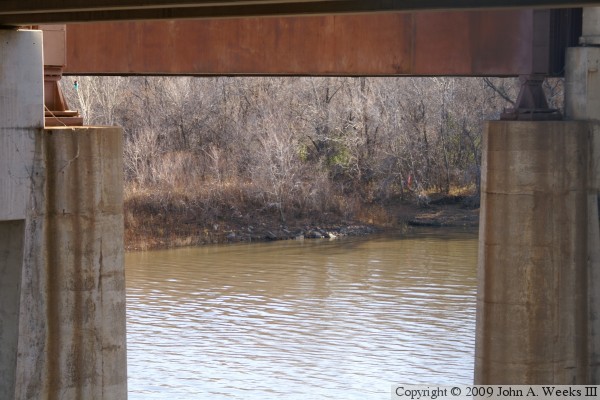
The photo below is looking across the main river channel to the location where the south bridge abutment once stood. Much of the roadway on the south side of the river is still intact, however the list 140 feet near the river is overgrown. The photo below is an interpretative sign located at the trailhead on the north end of the Long Meadow Bridge.

Old Cedar Avenue Bridge

Made With Macintosh
Authored by John A. Weeks III, Copyright © 1996—2016, all rights reserved.
For further information, contact: john@johnweeks.com