Current Weather Conditions
John A. Weeks III
Tuesday, March 19, 2024, 3:03:12 AM CDT
Home Photo Tours Rail Fan 12 Easy Steps
Aviation Spacecraft Highways & Bridges About The Author
 
Google Search
Maps   Groups   Images   Search
 
  Home
  • 12 Easy Steps
  • Aviation
  • Spacecraft
  • Highways & Bridges
    » Bridge Photography
      - MSP River Bridges
        › 10th Avenue Bridge
        › Arcola High Bridge
        › Betty Adkins Bridge
        › Bloomington Ferry
        › Bloomington Fry Tr
        › BNSF RR Bridge
        › Boom Island Foot Br
        › Broadway Avenue Br
        › C&NW Bridge (1)
        › C&NW Bridge (2)
        › Camden Bridge
        › Cedar Avenue Bridge
        › Cedar Ave Br (Old)
        › Cedar Ave Bicycle Br
        › Cedar Bend RR Br
        › Chaska Bridge (Old)
        › Chaska Swing Bridge
        › Chaska Trestle
        › Coon Rapids Dam
        › CP RR Bridge
        › Dan Patch Line Br
        › Dartmouth Bridge
        › East Channel Bridge
        › East Channel RR Br
        › East River Flats Br
        › Endless Bridge
        › F. W. Cappelen Mem
        › Father Henn Bluffs
        › Father Louis Henn Br
        › Ferry Street Bridge
        › First Avenue Bridge
        › Fort Road Bridge
        › Fort Snelling Br (Old)
        › Fort Snelling High Br
        › Great Western Bridge
        › Grey Cloud Channel
        › Grey Cloud Island Br
        › Grey Cloud Trail Br
        › Hastings High Bridge
        › Hastings Spiral Br
        › Holmes St Ped Bridge
        › Highway 243 Bridge
        › I-35W Bridge
        › I-35W Bridge (Old)
        › I-494 Bridge
        › I-694 Bridge
        › Interstate Bridge
        › Intercity Bridge
        › L St. Anthony F L&D
        › Lafayette Bridge
        › Lake Street Bridge
        › Lewis Street Bridge
        › Lexington Bridge
        › Lions Levee Pk Foot
        › Lock & Dam #1
        › Lock & Dam #2
        › Long Meadow Bridge
        › Lower Bridge
        › Lowry Bridge (Old)
        › Meeker Island L&D
        › Mendota Bridge
        › Merriam Street Br
        › Mill Ruins Park Br
        › Milwaukee Road Br
        › M&StL Bridge
        › Miss River Bridge 15
        › MN-101 Bridge
        › MN-41 Backchannel
        › MN-41 Back Ch (Old)
        › MN-41 Bridge
        › New Saint Croix Br
        › New Trunk-41 Bridge
        › Nicollet Island RR Br
        › North Miss Park Pier
        › NP Bridge #9
        › NP RR Bridge
        › Pike Island Bridge
        › Plymouth Bridge
        › Point Douglas DB
        › Raspberry Island Br
        › Richard P. Braun Br
        › Robert Street
        › Rock Island Swing Br
        › Runway 30 Light Br
        › Short Line Bridge
        › Smith Avenue High
        › Southeast Steam Plant
        › St. Anthony Falls Br
        › St. Anthony Falls Lab
        › St. Anthony Falls PP
        › St. Croix Boom Site
        › St. Croix Falls Dam
        › Stillwater Lift Br
        › Stone Arch Bridge
        › Third Avenue Bridge
        › Toll Bridge (Old)
        › U St. Anthony F L&D
        › US-8 Bridge
        › Wabasha Street Bridge
        › Wakota Bridge
        › Wakota Bridge (Old)
        › Walnut Street CW
        › Washington Ave Br
        › WI Central RR Br
        › WI Central RR Ruins
        › Wright Co Hwy 42
      - C & D Canal
      - Illinois River
      - Minnehaha Creek
      - Minnesota River
      - Mississippi River
      - Missouri River
      - St. Croix River
      - St. Louis River
      - Wisconsin River
      - Best Miss River Photos
      - Cable Stayed Bridges
      - McGilvray Road Bridges
      - I-35W Bridge Disaster
      - Miscellaneous Bridges
      - Madison County Bridges
      - Hist Br Weekend 2013
    » Road Geek Topics
  • Photo Tours
  • Rail Fan
  • About The Author
 
Site Search By JRank
Highways, Byways, And Bridge Photography
Smith Avenue High Bridge
MN-149 Mississippi River Crossing
Saint Paul, MN

MN-149 Bridge

• Structure ID: NBI: 62090.
• Location: River Mile 840.50.
• River Elevation: 686 Feet.
• Highway: Smith Avenue, MN-149.
• Daily Traffic Count: 16,500 (2002).
• Bridge Type: Steel Girder with 2 Steel Arches.
• Length: 2,769.7 Feet, 520 Foot Main Span.
• Width: 2 Traffic Lanes, 54.3 Feet.
• Navigation Channel Width: 210 Feet.
• Height Above Water: 149 Feet (Low Steel), 160 Feet (From Deck).
• Date Built: Opened July 1987.

The first bridge at this location, also called the High Bridge, was opened in 1889. It was constructed of wrought iron, and was supported by tall iron towers. The main river spans consisted of 4 Warren truss sections each 250 feet long. The north approach was a riveted viaduct of 80 foot spans and plate girder spans of 40 feet. The south approach had two 60 foot plate girder spans and one 170 foot pin connected girder span. The piers consisted of 4 leg towers and 2 leg bents.

On the night of August 20, 1904, the south spans and one main span of the bridge collapsed during a powerful thunderstorm. The collapse was investigated by the American Society of Civil Engineers, with the final report being written by famous bridge designer C. A. P. Turner. The report states that a bridge failing from wind along is a very rare event. It further states that the bridge itself was strong enough to stand up to even higher winds. The problem was that the supporting towers were not anchored to the concrete foundations, but rather, were simply resting on the foundations and help in place by gravity. The wind was able to push one of the support towers off of its foundation, causing the collapse.

The high bridge was rebuilt, this time, using steel rather than iron. The bridge served traffic for nearly a century, and probably would have served even longer if it had not been for the Silver Bridge disaster in Ohio in just before Christmas in 1967. The final verdict on the Silver Bridge collapse was that a pin had failed due to a materials defect. The pin was non-redundant, which means that when it failed, the entire bridge failed. Further, the pin was in a location where it could not be inspected. The problem is that the High Bridge was rebuilt using pin connected truss spans. The worry was that these pins were no longer safe, and could not be inspected to know whether or not they were safe. As a result, in the summer of 1984, MN-DOT Commissioner Richard Braun made the decision to close the high bridge. The bridge was imploded on February 25, 1985. When the wreckage was recovered and examined, the connector pins were found to be in excellent condition.

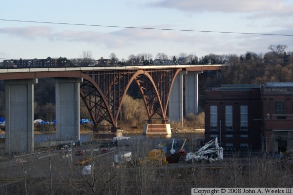
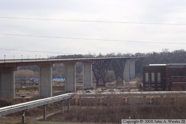
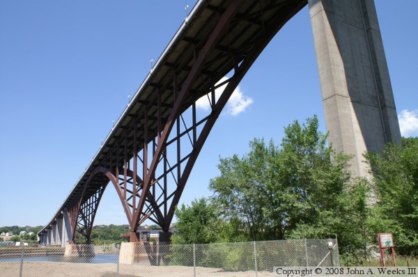
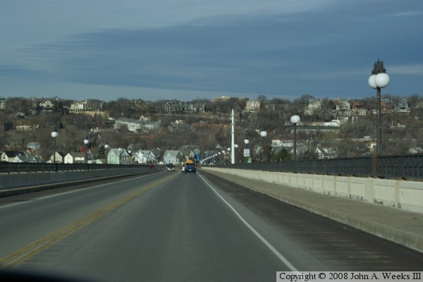
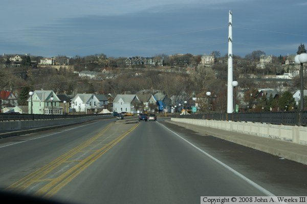
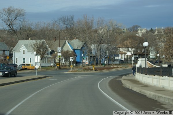
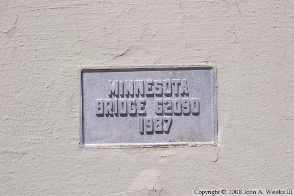
With their bridge now gone, residents of West Saint Paul lobbied hard for a new bridge to restore their access to the West 7th Street area of Saint Paul. The new bridge opened in 1987, and was heralded as one of the seven engineering wonders of Minnesota. It is a magnificent structure towering 160 feet above the river, making it the highest bridge in the city of Saint Paul. The huge steel supports under the bridge looked like a giant letter W, with the two bottom points sitting on piers, and the center forming a large steel arch. To appease the locals who fondly remembered the old High Bridge, MN-DOT incorporated some of the iron salvaged from the old bridge to manufacture the railings for the new bridge.

As soon as it got cold, the bridge contracted a little more than was planned, and one of the steel sections shifted, causing the center point of the W to no longer meet. Instead, the two beams shifted 11 inches, leaving a huge drop-off on the bridge. The bridge was closed several months while engineers designed a way to move the arches back into position and remove the ski-jump from the roadway.

A newspaper account from January 22, 1962, states that a car left the old high bridge, landed upside down on a telephone line, was sprung back up into the air, and landed upright with no passenger injuries. I guess that is what makes winter driving so much fun in Minnesota.

Smith Avenue is named after Robert Smith, who was the mayor of the city of Saint Paul from 1887 to 1892, 1894 to 1896, and from 1900 to 1908.

The photo at the top of this page was taken from a small park at the corner of Summit Avenue and Ramsey Street. This photo from the winter of 2006 was taken from the top of the river bluffs, resulting in a scene that almost looks like an aerial photograph.


MN-149 Bridge
The photo above is a view looking southwest from the deck of the Wabasha Street Bridge. The photo below is a view from Cherokee Avenue near the southeast corner of the bridge. The smokestack on the far side of the river was taken down with explosives in the summer of 2008, and the steam plant was demolished during 2009.

MN-149 Bridge
MN-149 Bridge
These two photos were taken from the same location on Cliff Street overlooking the river gorge. The photo above is a close view of the main river channel taken in the fall of 2008. The photo below is a view of about two-thirds of the overall bridge from the fall of 2006. The steam pipe in the photo below was removed in the summer of 2008 after the steam power plant was taken off-line and retired.

MN-149 Bridge
MN-149 Bridge
These two photos demonstrate how lens side effects can change the look of a photo. When using a wide angle lens, the background is made smaller and the foreground is exaggerated. The bridge itself is taller on the east side of the river than on the west side of the river. In the photo above taken from the east side of the river, the near pier looks higher than in real life, but the background looks shorter than in real life. The result is that the bridge looks far more slanted it really is. Likewise in the photo below taken from the west side of the river, the near pier looks a bit higher than it should, and the far pier a little lower than it should, resulting in a photo where the bridge looks level rather than slated upward as you look across the river.

MN-149 Bridge
MN-149 Bridge
These two photos are the first of six photos that show a typical crossing of the Smith Avenue High Bridge. In this series of photos, we start at the southeast end of the bridge, and head northwest into Saint Paul. The photo above would be the west portal of the bridge, except that the river is running south to north in this area, so it is the southeast end of the bridge. This photo shows the nice monuments and stone work at the entrance to the bridge. The photo below is just after entering the bridge. Notice the wide curb in the middle of the roadway, which tapers to an end shortly ahead.

MN-149 Bridge
MN-149 Bridge
In these two photos, we continue our crossing of the Smith Avenue High Bridge. In the photo above, we are about one-third of the way across the bridge high over the main river span. In the photo below, we are about two-thirds of the way across the bridge, just passing the old High Bridge Steam Generating Plant.

MN-149 Bridge
MN-149 Bridge
These two photos are the final views of our crossing of the Mississippi River over the Smith Avenue High Bridge. In the photo above, we are nearing the end of the bridge. In the photo below, we are just about to exit the northwest end of the bridge. Notice that the street is once again divided with turn lanes in the center.

MN-149 Bridge
MN-149 Bridge
The photo above is the traffic deck on the south end of the bridge. There is a wide median on the south end, which taper down to a point near the middle of the main span. The photo below is the bridge plate that gives the bridge state ID number and date of construction.

MN-149 Bridge

Made With Macintosh
Authored by John A. Weeks III, Copyright © 1996—2016, all rights reserved.
For further information, contact: john@johnweeks.com