Current Weather Conditions
John A. Weeks III
Sunday, August 1, 2010, 5:38:18 AM CDT
Home 12 Easy Steps Random Topics About The Author Portal
Aviation Spacecraft Highways & Bridges Photo Tours Rail Fan

Google Search

 Maps  Groups
 Images  Search
  Home
  • 12 Easy Steps
  • Aviation
  • Spacecraft
  • Highways & Bridges
    » Bridge Photography
      - MSP River Bridges
        › 10th Avenue Bridge
        › Arcola High Bridge
        › Betty Adkins Bridge
        › Bloomington Ferry
        › Bloomington Fry Tr
        › BNSF RR Bridge
        › Boom Island Foot Br
        › Broadway Avenue Br
        › C & NW Bridge (1)
        › C & NW Bridge (2)
        › Camden Bridge
        › Cedar Avenue Bridge
        › Cedar Ave Br (Old)
        › Cedar Ave Bicycle Br
        › Cedar Bend RR Br
        › Chaska Bridge (Old)
        › Coon Rapids Dam
        › CP RR Bridge
        › Dan Patch Line Br
        › Dartmouth Bridge
        › East Channel Bridge
        › East Channel RR Br
        › East River Flats Br
        › F. W. Cappelen Mem
        › Father Henn Bluffs
        › Father Louis Henn Br
        › Ferry Street Bridge
        › First Avenue Bridge
        › Fort Road Bridge
        › Fort Snelling Br (Old)
        › Fort Snelling Br (Foot)
        › Fort Snelling High Br
        › Great Western Bridge
        › Grey Cloud Channel
        › Grey Cloud Island Br
        › Grey Cloud Trail Br
        › H&D RR Bridge
        › H&D RR Trestle
        › Hastings High Bridge
        › Hastings Spiral Br
        › Holmes St Ped Bridge
        › Highway 243 Bridge
        › I-35W Bridge
        › I-35W Bridge (Old)
        › I-494 Bridge
        › I-694 Bridge
        › Interstate Bridge
        › Intercity Bridge
        › L St. Anthony F L&D
        › Lafayette Bridge
        › Lake Street Bridge
        › Lexington Bridge
        › Lions Levee Pk Foot
        › Lock & Dam #1
        › Lock & Dam #2
        › Long Meadow Bridge
        › Lower Bridge
        › Lowry Bridge (Old)
        › Meeker Island L&D
        › Mendota Bridge
        › Merriam Street Br
        › Mill Ruins Park Br
        › Milwaukee Road Br
        › M&SL RR Bridge
        › Miss River Bridge 15
        › MN-101 Bridge
        › MN-41 Backchannel
        › MN-41 Back Ch (Old)
        › MN-41 Bridge
        › New Saint Croix Br
        › New Trunk-41 Bridge
        › Nicollet Island RR Br
        › North Miss Park Pier
        › NP Bridge #9
        › NP RR Bridge
        › Plymouth Bridge
        › Point Douglas DB
        › Raspberry Island Br
        › Richard P. Braun Br
        › Robert Street
        › Rock Island Bridge
        › Runway 30 Light Br
        › Shakopee Bridge
        › Short Line Bridge
        › Smith Avenue High
        › Southeast Steam Plant
        › St. Anthony Falls Br
        › St. Anthony Falls Lab
        › St. Anthony Falls PP
        › St. Croix Boom Site
        › St. Croix Falls Dam
        › Stillwater Lift Br
        › Stone Arch Bridge
        › Third Avenue Bridge
        › Toll Bridge (Old)
        › U St. Anthony F L&D
        › US-8 Bridge
        › Wabasha Street Bridge
        › Wakota Bridge
        › Wakota Bridge (Old)
        › Walnut Street CW
        › Washington Ave Br
        › WI Central RR Br
        › WI Central RR Ruins
        › Wright Co Hwy 42
      - Illinois River
      - Minnehaha Creek
      - Minnesota River
      - Mississippi River
      - Missouri River
      - St. Croix River
      - St. Louis River
      - Wisconsin River
      - Cable Stayed Bridges
      - McGilvray Road
      - I-35W Bridge Disaster
      - Miscellaneous Bridges
    » Road Geek Topics
  • Random Topics
  • Photo Tours
  • Rail Fan
  • About The Author
  • John's Portal
 
Site Search By JRank
Highways, Byways, And Bridge Photography
Fort Snelling High Bridge (Old)
Historic Mississippi River Crossing
Saint Paul, MN

Fort Snelling High Bridge (Old)

• Structure ID: N/A.
• Location: River Mile 845.6.
• River Elevation: 686 Feet.
• Highway: Fort Road.
• Daily Traffic Count: 0 (Bridge Has Been Removed).
• Bridge Type: Iron Deck Truss Bridge.
• Length: 1,075 Feet (Estimated).
• Width: 2 Traffic Lanes.
• Navigation Channel Width: 250 Feet (Estimated).
• Height Above Water: 80 Feet (Estimated).
• Date Built: 1880.
The Mississippi River crossing north of Fort Snelling has a long history. The area near the fort was an anchor for early settlement, while Saint Paul developed early due to being the practical northern end of where steam boats could travel. The road between Saint Paul and the fort was heavily traveled. The government opened a cable style ferry boat as early as 1844. According to the text on the historical marker, this ferry operated until 1880.

The Omaha Road railroad established a station at Fort Snelling around 1870, but the railroad crossed the Minnesota River, not the Mississippi River. The Mississippi River crossing for trains was a few miles down river.

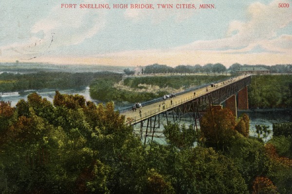
The first bridge built across the Mississippi at this location was the Fort Snelling High Bridge. It was a rickety iron wagon bridge. It was built on tall masonry piers, and was supported by a web of beams and cables. The wagon deck sat on top of this truss. This bridge was finished in 1880. It could not handle the load of trolley cars, so it was removed and replaced in 1909.

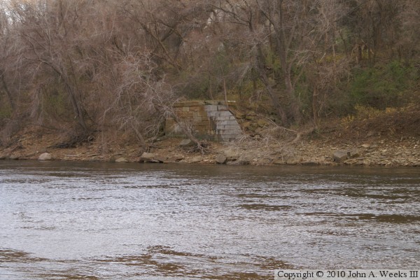
The photo above is a view of a structure that is believed to be the remains of the base of a support pier on the Fort Snelling side of the river. In addition to this pier support, part of the bridge abutment and retaining walls exist on the grounds of Fort Snelling.

The image below is a postcard depicting the Fort Snelling High Bridge. This image is based on a painting, so it is an idealized view of the scene.


Fort Snelling High Bridge (Old)

Made With Macintosh
Authored by John A. Weeks III, Copyright © 1996—2010, all rights reserved.
For further information, contact: john@johnweeks.com