In the middle 1800s, transportation on the major rivers was dominated
by the riverboats, and to a lessor extent, the raftsmen who carried
goods one-way down the river. Saint Paul was the head of navigation on
the great river in that era. Minneapolis had the falls, the best
natural falls for creating mechanical power in North America, but it
could not get the goods created by that power of the falls to market.
An eight mile long section of rocks and rubble prevented the river boats
from going any further north than Fort Snelling.
Even before the Civil War, local leaders dreamed of taming the river
and bringing river navigation to Minneapolis. In 1857, a local judge
named Bradley Meeker organized a group of businessmen to build a lock and
dam on the Mississippi River. A financial panic, civil war, and
reconstruction got in the way. Congress came on board in 1873, but
local politics stalled the project another 20 years. Finally, the
invention of electricity and hydropower only served to add to the
debate. Both Saint Paul and Minneapolis wanted the hydropower from
this section of the river.
A compromise was struck. Two lock and dam structures would be built.
Lock & Dam #1 would be at the location of the current Lock & Dam #1
near the Ford Motor Plant. Lock & Dam #2 would be upriver, just above
Lake Street, and be located totally within the City of Minneapolis, at
a location near an island named after Bradley Meeker.
Construction began in 1899, and Lock & Dam #2 opened in 1907. Work
then focused on Lock & Dam #1, which was about half done at that time.
Both were low water dams with a water fall of about 14 feet.
The hydropower question was raised again in 1909. The two low water dams
could not support hydropower generation. In addition, industry was pushing
Congress for a 9-foot navigation channel. The two locks could not
handle that depth of a channel. A decision was made to rebuild Lock
& Dam #1 as a high water dam. The hydropower would be sold to
investors, a deal that Henry Ford took advantage of.
The high water dam would have the side effect of flooding the newly
opened Lock & Dam #2. To prevent the submerged dam from being
a navigation hazard, the top 5 feet was blasted off in 1912. As a
result, Lock & Dam #2 was in operation only 5 years. The structure
was then promptly forgotten.
To avoid confusion with the current Lock & Dam #2 near Hastings,
MN, the old Lock & Dam #2 is now generally called the Meeker
Island Lock & Dam. Every so often, low water on the Mississippi
River exposes part of the old lock structure. One such occasion was
in August, 2007, following the I-35W bridge collapse, when the US Army
Corps of Engineers drew down the Ford Dam pool by 2 feet to aid in the
search and recovery operation. That action made it possible to photograph
some of the remains of the Meeker Island structure.
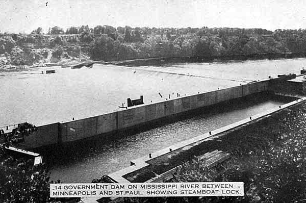
The image above is a postcard from the very early 1900s showing the
Meeker Island Lock & Dam in operation, and the newly rebuilt Short
Line Bridge in the background.
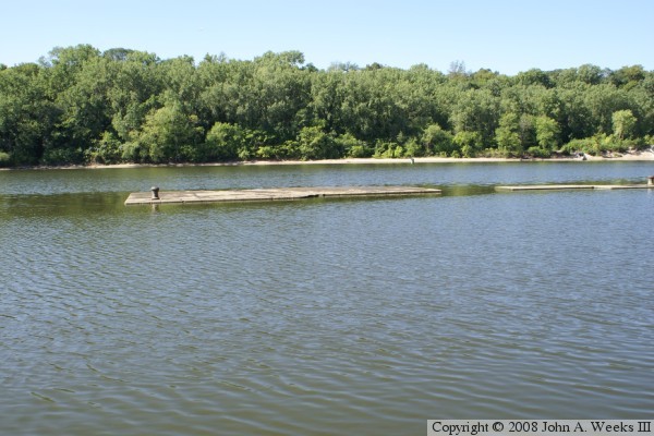
The photo above is a public domain photo of the Meeker Island Lock & Dam
in operation. The lock chamber is on the nearside of the river, and two
dam control gates are on the far side of the river. The photo below is the
downstream exit of the lock chamber. The two lock walls are 56 feet apart.
The photo above shows the end of the lock wall. The metal spindle is
a rope tie anchor. The thinner section of the wall near the small
gap is where the lock door would fold against the wall when the lock
was opened.
The photo below is looking upstream at the flooded lock chamber. The
lock chamber is estimated to be 400 feet long.
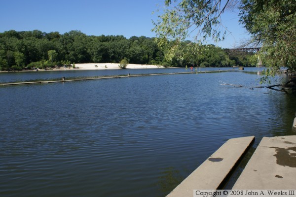
The photo above is looking across the river at the white sand beach.
The dam structure would be in the river below the beach.
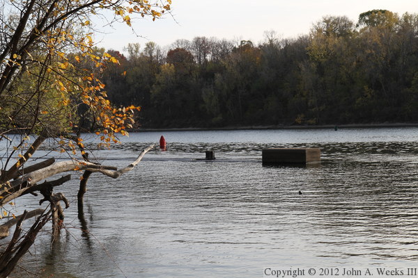
The photo below shows the upstream entrance to the lock.
The photo above is one more look at the upstream entrance to the lock. It is
interesting that this was once called Lock & Dam #2, but was up river from
Lock & Dam #1. Today, the locks and dams are numbered higher as you go
south, which is just the opposite of how the Meeker Island structure is
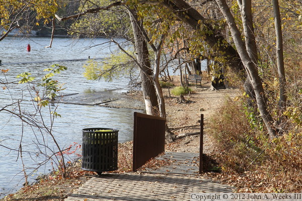
numbered. The National Park Service built a trail down to the lock site
and erected interpretive signs between 2005 and 2007. The photo below is
the sign along side East River Parkway at the top of the trail leading
down to the park.
The photo above is the trail leading down to the lock site. The trail has
a switchback. The park bench in the distance is only half way down to the
river level. The photo below is the end of the improved trail where it
arrives at the lock site. In 2010, City Pages rated the Meeker Island
Historical Park as the best place in the Twin Cities to have a picnic.
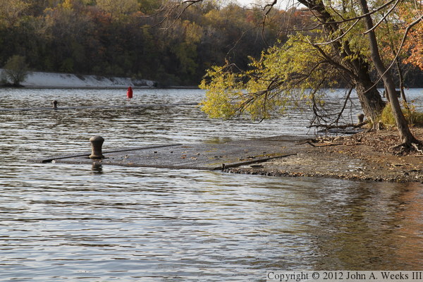
There was high water most of 2011, with the lock being underwater much of the
year. The top of the lock walls were only about an inch above water level
when I visited in late October of that year. The photo above is the west
wall that would have faced the river. The photo below is the east wall that
was along the shoreline.
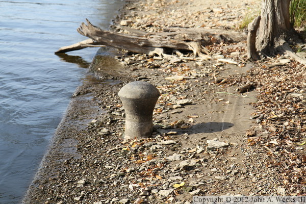
The photo above is a close view of one of the iron mooring posts. The photo
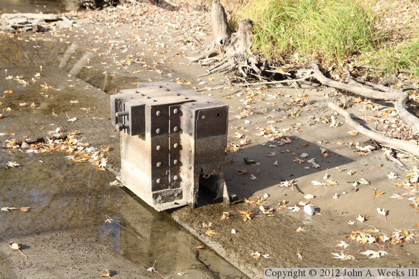
below is the only piece of mechanical remains that was visible. I have no
idea what this is, but it is located near the upstream end of the lock, so
it might have been part of the lock door mechanism.
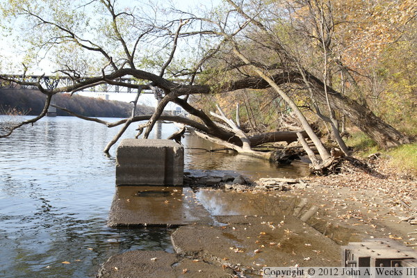
The photo above is looking north through the upstream end of the lock,
with the Short Line railroad bridge visible just upstream from the site.
The photo below is a closer view of the concrete remains at the upstream
end of the lock.
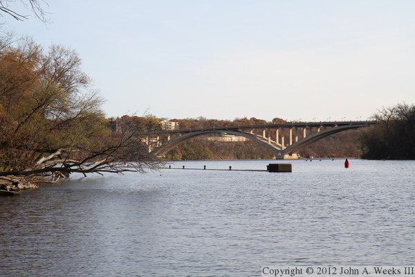
The photo above is looking downstream towards the upstream end of the lock.
The Lake Street Bridge is visible downstream of the lock & dam site.
The photo below is a closer view of the upstream entrance to the lock.