Current Weather Conditions
John A. Weeks III
Friday, July 26, 2024, 10:38:35 PM CDT
Home Photo Tours Rail Fan 12 Easy Steps
Aviation Spacecraft Highways & Bridges About The Author
 
Google Search
Maps   Groups   Images   Search
 
  Home
  • 12 Easy Steps
  • Aviation
  • Spacecraft
  • Highways & Bridges
    » Bridge Photography
      - MSP River Bridges
        › 10th Avenue Bridge
        › Arcola High Bridge
        › Betty Adkins Bridge
        › Bloomington Ferry
        › Bloomington Fry Tr
        › BNSF RR Bridge
        › Boom Island Foot Br
        › Broadway Avenue Br
        › C&NW Bridge (1)
        › C&NW Bridge (2)
        › Camden Bridge
        › Cedar Avenue Bridge
        › Cedar Ave Br (Old)
        › Cedar Ave Bicycle Br
        › Cedar Bend RR Br
        › Chaska Bridge (Old)
        › Chaska Swing Bridge
        › Chaska Trestle
        › Coon Rapids Dam
        › CP RR Bridge
        › Dan Patch Line Br
        › Dartmouth Bridge
        › East Channel Bridge
        › East Channel RR Br
        › East River Flats Br
        › Endless Bridge
        › F. W. Cappelen Mem
        › Father Henn Bluffs
        › Father Louis Henn Br
        › Ferry Street Bridge
        › First Avenue Bridge
        › Fort Road Bridge
        › Fort Snelling Br (Old)
        › Fort Snelling High Br
        › Great Western Bridge
        › Grey Cloud Channel
        › Grey Cloud Island Br
        › Grey Cloud Trail Br
        › Hastings High Bridge
        › Hastings Spiral Br
        › Holmes St Ped Bridge
        › Highway 243 Bridge
        › I-35W Bridge
        › I-35W Bridge (Old)
        › I-494 Bridge
        › I-694 Bridge
        › Interstate Bridge
        › Intercity Bridge
        › L St. Anthony F L&D
        › Lafayette Bridge
        › Lake Street Bridge
        › Lewis Street Bridge
        › Lexington Bridge
        › Lions Levee Pk Foot
        › Lock & Dam #1
        › Lock & Dam #2
        › Long Meadow Bridge
        › Lower Bridge
        › Lowry Bridge (Old)
        › Meeker Island L&D
        › Mendota Bridge
        › Merriam Street Br
        › Mill Ruins Park Br
        › Milwaukee Road Br
        › M&StL Bridge
        › Miss River Bridge 15
        › MN-101 Bridge
        › MN-41 Backchannel
        › MN-41 Back Ch (Old)
        › MN-41 Bridge
        › New Saint Croix Br
        › New Trunk-41 Bridge
        › Nicollet Island RR Br
        › North Miss Park Pier
        › NP Bridge #9
        › NP RR Bridge
        › Pike Island Bridge
        › Plymouth Bridge
        › Point Douglas DB
        › Raspberry Island Br
        › Richard P. Braun Br
        › Robert Street
        › Rock Island Swing Br
        › Runway 30 Light Br
        › Short Line Bridge
        › Smith Avenue High
        › Southeast Steam Plant
        › St. Anthony Falls Br
        › St. Anthony Falls Lab
        › St. Anthony Falls PP
        › St. Croix Boom Site
        › St. Croix Falls Dam
        › Stillwater Lift Br
        › Stone Arch Bridge
        › Third Avenue Bridge
        › Toll Bridge (Old)
        › U St. Anthony F L&D
        › US-8 Bridge
        › Wabasha Street Bridge
        › Wakota Bridge
        › Wakota Bridge (Old)
        › Walnut Street CW
        › Washington Ave Br
        › WI Central RR Br
        › WI Central RR Ruins
        › Wright Co Hwy 42
      - C & D Canal
      - Illinois River
      - Minnehaha Creek
      - Minnesota River
      - Mississippi River
      - Missouri River
      - St. Croix River
      - St. Louis River
      - Wisconsin River
      - Best Miss River Photos
      - Cable Stayed Bridges
      - McGilvray Road Bridges
      - I-35W Bridge Disaster
      - Miscellaneous Bridges
      - Madison County Bridges
      - Hist Br Weekend 2013
    » Road Geek Topics
  • Photo Tours
  • Rail Fan
  • About The Author
 
Site Search By JRank
Highways, Byways, And Bridge Photography
Betty Adkins Bridge
MN-101 Mississippi River Crossing
Elk River, MN

Betty Adkins Bridge

Northbound Span
• Structure ID: NBI: 86006.
• Length: 707 Feet, 150 Foot Longest Span.
• Width: 54 Feet, 2 Traffic Lanes.
• Date Built: Opened 2001, Replaced 1967 Structure.
 
Southbound Span
• Structure ID: NBI: 86005.
• Length: 706 Feet, 150 Foot Longest Span.
• Width: 42 Feet, 2 Traffic Lanes.
• Date Built: Opened 1993.
 
Southbound Entrance Ramp
• Structure ID: NBI: 86005A.
• Length: 293 Feet.
• Width: 29 Feet, 1 Traffic Lane.
• Date Built: Opened 1993.
 
Statistics Common To Both Spans
• Location: River Mile 882.8.
• River Elevation: 853 Feet.
• Highway: MN-101.
• Daily Traffic Count: 22,050 (2002).
• Bridge Type: Concrete Girder.
• Navigation Channel Width: Non-Navigable.
• Height Above Water: 16 Feet.
The MN-101 river crossing is known as the Betty Adkins Bridge due to a 1995 act of the Minnesota state legislature. Betty Adkins was a 12-year state senator from Saint Michael. She was known for bouncing back from several major setbacks and tragedy in her life.

Highway 101 originally crossed the Mississippi River just upstream at the CSAH-42 Parrish Avenue Bridge. MN-DOT desired to build a bypass around Elk River and connect MN-101 directly to US-169 to allow US-169 traffic an easy path to I-94. The result was a 2 lane bridge built in 1967. That was a steel plate girder bridge. A new concrete girder bridge was put down alongside the 1967 structure in 1993, and the 1967 structure became dedicated to northbound traffic. This left the odd situation of one bridge having steel girders, while the twin had concrete girders. The 1967 bridge was replaced in 2001 with another concrete girder bridge that really does look like a twin to the 1993 bridge. The CSAH-42 bridge was replaced in 1985, so the CSAH-42 bridge that stands today did not carry the MN-101 designation, but its predecessor did.

The National Bridge Inventory considers this to be three bridges. The southbound span was built in 1993, while the northbound span opened in 2001. The southbound span has an on-ramp that joins the main southbound span over water. NBI considers this on-ramp to be a separate bridge, and it has its own NBI number.

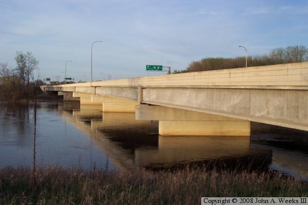
The photo above and photo below were taken during the spring of 2005 during the high water season. Due to the late evening time, the only view of the bridge that was available was from the southwest corner looking towards the north. The photo above is view of the bridge at the river level, while the photo below is a view of the bridge from the traffic deck. The north end of the bridge flares out into an interchange with US-169 and US-10.


Betty Adkins Bridge
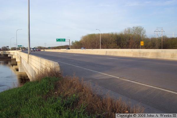
The photo above is a view of the older of the two spans, looking north across the Mississippi River. The photo below is the start of a typical river crossing heading north. This trip will cross the newer of the two bridge spans. The approach road from the south is under construction as part of the project to upgrade MN-101 to be a 4-lane freeway.

Betty Adkins Bridge
Betty Adkins Bridge
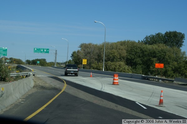
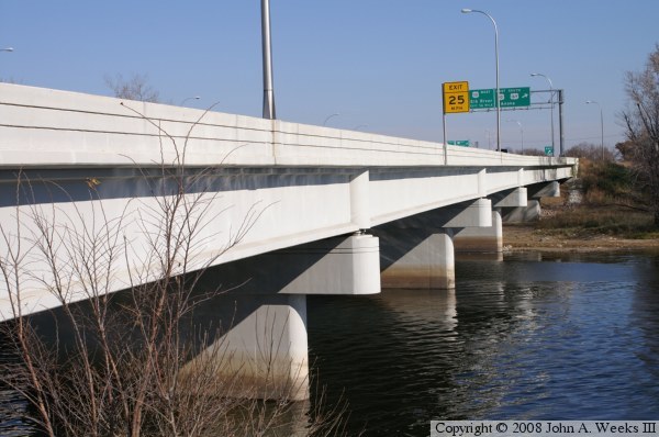
These two photos, taken in the fall of 2008, continue our crossing of the Betty Adkins Bridge heading northbound. In the upper photo, we are about halfway across the bridge. The big green sign indicates that we 
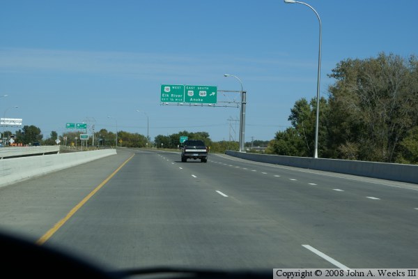
have options for US-10 and US-169 as well as staying on MN-101. In the photo below, the ramp to the right carries traffic to southbound US-169 and eastbound US-10. The mainline traffic now has the choice to exit to US-10 westbound or continue on northbound US-169. MN-101 ends just around the bend in the highway.

Betty Adkins Bridge
Betty Adkins Bridge
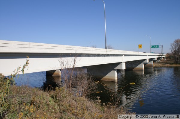
These photos are two views taken in the fall of 2006. The water is much lower than the spring of 2005 photos. In fact, the 4th pier is high and dry in these photos, while they were at the edge of the river in the photos at the top of this page. These views are of the newer span, taken from the southeast corner of the bridge looking to the north.

Betty Adkins Bridge
Betty Adkins Bridge
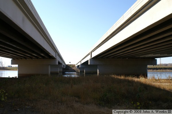
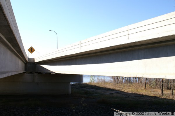
These two photos are views from under the north end of the bridge. The newer northbound span is on the left, while the older southbound span is on the right. The ground at this location was under water in the spring of 2005 photos at the top of this page.

Betty Adkins Bridge
Betty Adkins Bridge
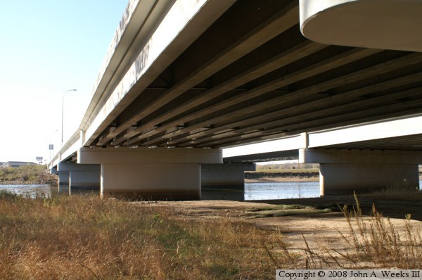
The photo above is view under the northbound span looking to the southwest. It is interesting that the two bridges look nearly identical despite being built 12 years apart. The photo below shows the merger of the southbound span (on the left) and the entrance ramp bridge from US-10 (on the right). The merger looks like a smooth curve to the bridge traffic, but from this vantage point, we can see that the bridges are built from straight sections of materials.

Betty Adkins Bridge

Made With Macintosh
Authored by John A. Weeks III, Copyright © 1996—2016, all rights reserved.
For further information, contact: john@johnweeks.com