| Highways, Byways, And Bridge Photography |
Rock Island Swing Bridge Recreational Pier
Mississippi River Recreational Pier
Inver Grove Heights, MN
|
• Structure ID: |
NBI: 5600 (1895 Spans), ??? (2010 Spans). |
|
• Location: |
River Mile 830.3. |
|
• River Elevation: |
686 Feet. |
|
• Bridge Type: |
Steel Through Truss, Wood Deck. |
|
• Length: |
670 Feet, 250 Foot Longest Span. |
|
• Width: |
18 Feet (1895 Spans), ??? (2010 Spans). |
|
• Navigation Channel Width: |
Pier Does Not Cross The Navigation Channel. |
|
• Height Above Water: |
19 Feet. |
|
• Date Built: |
Opened June 8, 2011, Using 1895 And 1970 Ruins. |
The Rock Island Swing Bridge Recreational Pier is an observation deck and
fishing pier that is built using two spans and several piers from the original
1895 vintage Rock Island Swing Bridge. Click
here for more information on the swing bridge and
the events leading to its demolition.
A collapse at the east end of the Rock Island Swing Bridge in the fall of
2008 put the project to demolish the bridge into high gear. By the spring
of 2009, the Viet Companies were on the job and rapidly taking down sections
of the bridge. Even as the contractors were demolishing the Rock Island Swing
Bridge in 2009, there were still those who had hoped to save this 114 year old
structure. Key players included the City of Inver Grover Heights and the
National Park Service. By the summer of 2009, only two spans on the western
side of the navigation channel remained standing.
Just as Dakota County was preparing to engage contractors to remove the last
two bridge spans, the State of Minnesota enacted a new bonding bill that
included a two year moratorium on any further demolition work. This allowed
time for the City of Inver Grove Heights to take title to the bridge, and
for the project team to raise over $2-million to turn the remaining bridge
spans into a recreational pier. Funding came in from several sources,
including $1.3-million in federal grants and $300,000 in city money. In
addition, local businesses and the general public were invited to become
project partners, and even school kids got involved in the lobbying and fund
raising efforts.
The pier is 670 feet long. This includes the two original 1895 spans that
are each 140 feet long, one new span of 140 feet, and a new span of 250
feet. One of the new spans is 140 feet since it reuses one of the old bridge
piers. The 1895 spans are typical through truss spans, but with additional
vertical beams to support the upper deck that once carried rail traffic.
The 2010 spans were fabricated in a factory and hauled to the site for
installation. They are very heavy through truss spans. The west bridge
abutment and approach are new construction.
Disaster struck the project on November 4, 2010. As the project was
nearing completion, sparks from a welder's torch set the bridge deck on
fire in the 1895 spans. High winds that day made the fire hard to fight,
as did the location of the fire. The bridge deck was old wood that had
been soaked in a preservative. Later, a layer of tin was put down over the
wood, and then an asphalt overlay was put down over the tin. The fire got
into the wood under the pavement, and could only be fought from below. The
bridge deck was totally destroyed.
A few days after the fire, the project manager announced two very good
pieces of news. First, the bridge structure itself hadn't been damaged.
Second, the contractor had insurance for the damage. The project would
move forward, with repairs to the steel deck supports and a new deck. The
only downside is that project completion would be delayed until June, 2011,
after having already been delayed by a rare late fall flood in 2010. In
early 2011, the project again was threatened by state government budget
issues. The project was suggested as a cut, but city officials were able
to convince the state to keep the existing funding in place.
The end result of the Rock Island Swing Bridge Recreational Pier project is
structure that will serve as the focal point for a 55 acre historical park
that is being planned by Inver Grove Heights. The park will be one of the
few places that you can access the Mississippi River on public land between
Interstate highway I-494 and Hastings, Minnesota. Yet to come is a second
parking area, a park shelter, and a display of historical artifacts salvaged
from the demolished bridge.
The new Rock Island Swing Bridge Recreational Pier had its grand opening
ceremony on the afternoon of June 8, 2011. The pier opened to the
general public at 5:30 PM following the ribbon cutting.
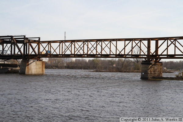
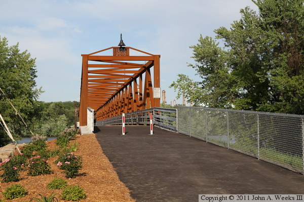
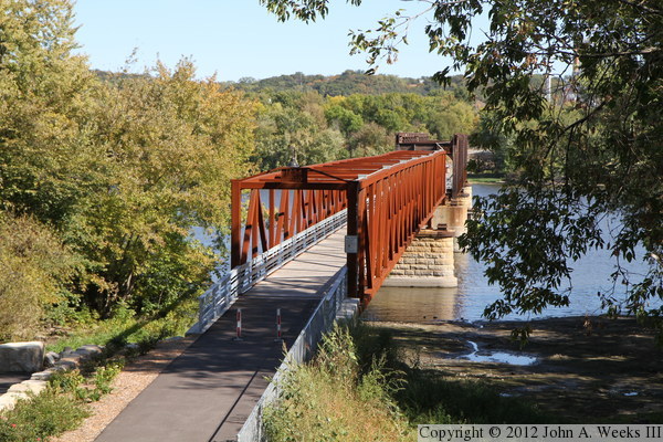
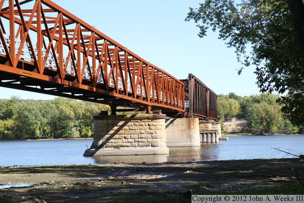
The photo above is looking east across the Mississippi River towards the
west end of the new Rock Island Swing Bridge Recreational Pier. The
bridge abutment is new. Looking out into the river, the first pier is an
original 1895 pier, the second pier is a 1970 era pier, the third pier
is an 1895 pier that has been reinforced with a sheet pile and concrete
jacket, and the fourth pier is an original 1895 pier.

These two photos are additional views of the west end of the Rock Island
Swing Bridge Recreational Pier, as seen on the day after the November, 2010,
fire. The new spans were not damaged by the fire. The bridge was only
three weeks from opening at this point, with little work remaining other
than grading and paving. The project would have been completed already
if it hadn't been for an unusual late season flood. Instead, the project
will be completed in the spring of 2011.


The photo above is a view of the entire pier seen on the day after the fire,
while the photo below is a close view of the damaged spans. The bridge floor
was timber that was covered with a layer of sheet steel covered with asphalt
pavement. The fire got under the sheet steel and burned the wood supports,
allowing the sheet steel and pavement to sag and drop into the river. Barges
were moved in to allow the flooring to be removed without putting yet more
debris into the Mississippi.

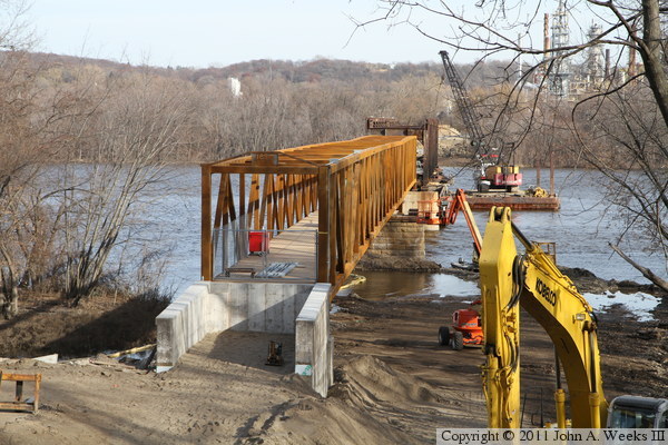
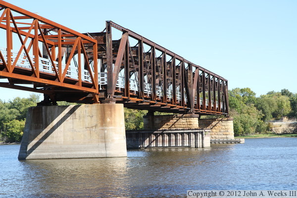
The photo above is the eastern of the two new through truss bridge spans.
This is a prefabricated span that built in a factory and delivered to the
site for erection. The photo below is the first bridge pier on the west
end of the structure, which is an original 1895 pier. An earthen causeway
was built out to the first pier to support construction equipment. That
causeway will be removed before the pier opens to the public.

These two photos show construction progress as of mid-April, 2011. The
site work and grading is nearly complete, and work is progressing on
installing a new deck on the original bridge spans. The vantage point
for these photos is the end of the old railroad embankment, which is
about 20 feet above the level of the old roadway, or about the same
height as the top of the bridge trusses.

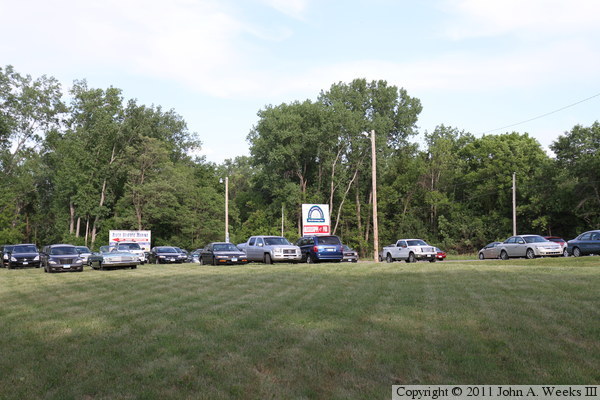
These two photos, and the 22 that follow, were taken on the afternoon of
June 8, 2011, just after the 5:30 PM ribbon cutting that opened the Rock
Island Swing Bridge Recreational Pier to the public. The photo above is
cars parked on the grass near the entrance road to the site. The photo
below is an overview of the west end of the bridge. The tent and other
facilities were set up for the ribbon cutting ceremony.

These two photos are views of the west bridge abutment leading to the
portal at the west end of the structure. The area is nicely landscaped.
High water from a second crest of the spring flood prevented views from
the side of the abutment or under the bridge.

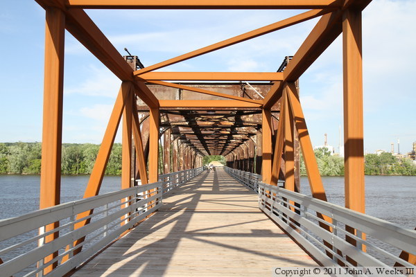
The photo above is the west bridge portal. The first span is one of two
bridge truss spans that were built in 2010. The photo below is looking
southeast through the side of the truss structure. The facility on the
far side of the river is the Saint Paul Park Refinery, which was recently
purchased from the Marathon Petroleum Company by Northern Tier Energy,
which owns the SuperAmerica chain.

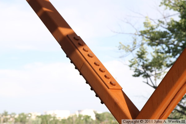
The 2010 vintage spans were prefabricated in a factory in sections, trucked
to the site, assembled, and set in place by a crane. The longer bridge
span was built in five sections. These two photos are field joints
where two sections were joined. The photo above is a smaller beam that
runs at a 45-degree angle, while the photo below is a horizontal beam at
the top of the truss structure.


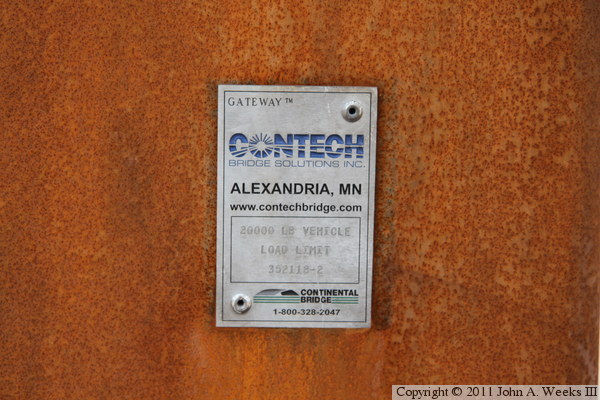
These two photos are the bridge plates for the 2010 vintage bridge spans.
The photo above is the longer span at the west end of the bridge, while
the photo below is the shorter span that connects to the 1895 era structure.
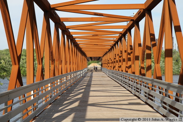
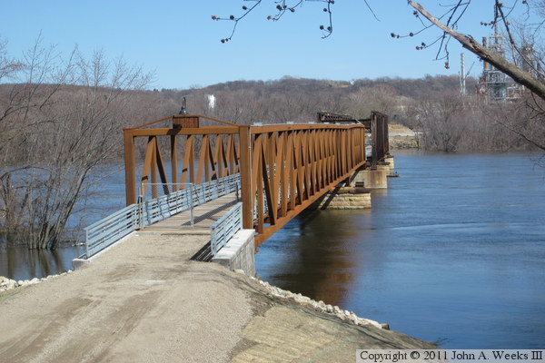
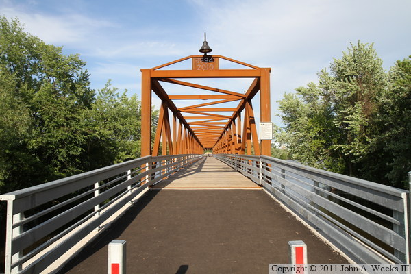
The photo above is looking east down the length of the Rock Island Swing
Bridge Recreational Pier from very near the west bridge portal. The photo
below is a similar view showing the transition from the 2010 era bridge
spans to the 1895 era structure.

The photo above is looking back to the west at the transition between
the 1895 era structure and the 2010 era bridge spans. The photo below
is looking northeast through the side of the 1895 era truss structure.
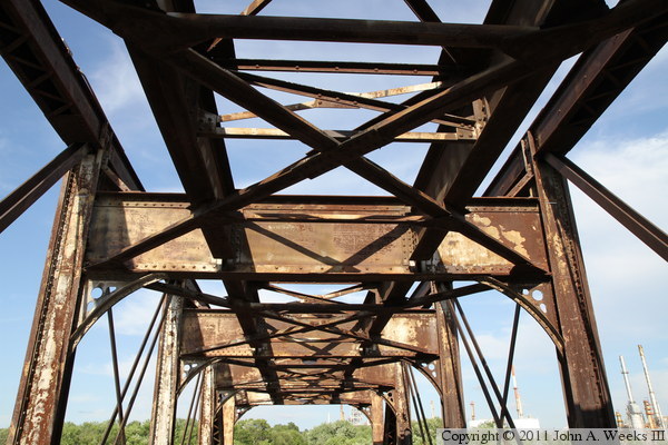
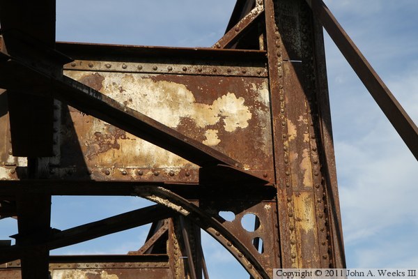
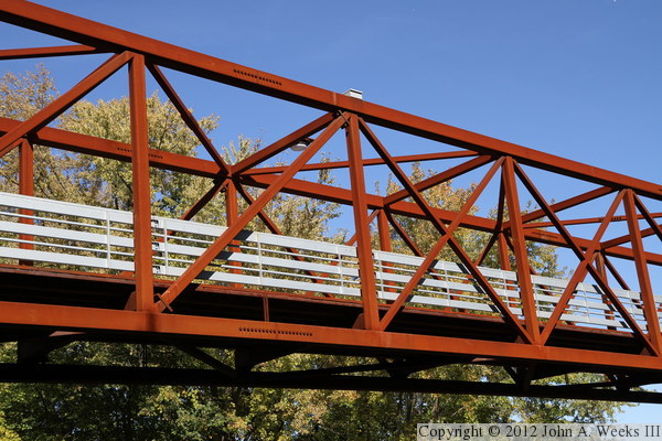
These two photos are looking towards the top of the 1895 era truss structure.
The railroad track once ran on the upper deck. As a result, there are
large beams at the top of the truss, plus additional stringers running the
length of the upper deck that once supported the wooden ties that held the
rails in place. The photo below is a closer view of a large horizontal
beam at the top of the truss. While there is a lot of rust visible, it
is all surface rust, which has not compromised the strength of the bridge.
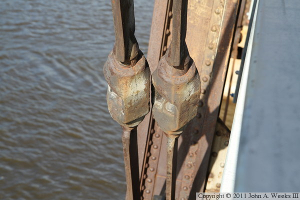
These two photos are detail views of interesting structural elements on
the 1895 era bridge spans. The photo above are a pair of turnbuckles that
can be used to tighten connecting rods that help support the truss
structure. The photo below is a connector pin that joins a number of
beams and rods, plus supports a stringer that holds up the bridge deck.

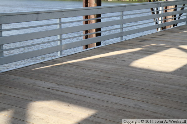
The photo above is a close view of the bridge deck on the 1895 era bridge
spans. The wood is new since the deck was replaced after the fire in
late 2010. The photo below is looking east down the length of the
easternmost bridge span.

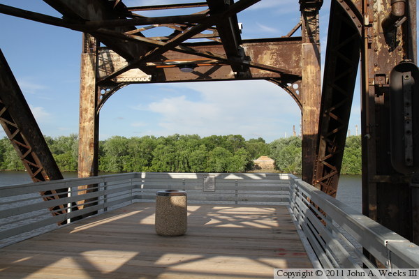
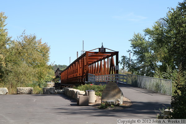
The photo above is the east end of the pier. The photo below is looking
east across the Mississippi River from the end of the pier. The stone work
on the east river bank is a pier and the east abutment from the swing
bridge. The bridge section on the east side of the river collapsed in
November, 2008, and the structure in that area was removed in early 2009.

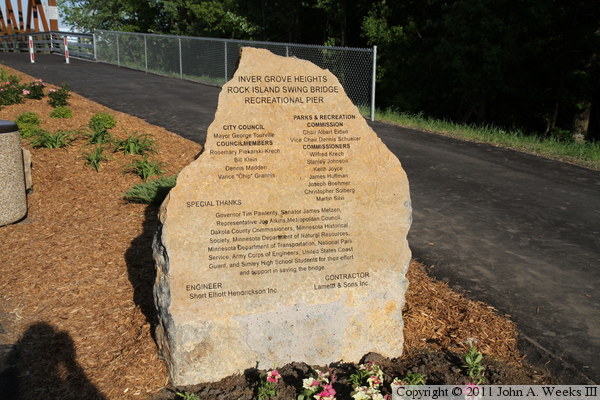
The photo above is a marker stone that includes the names of local
government officials, plus people and organizations that worked on the
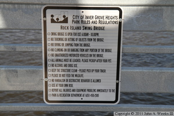
project. The photo below is a sign with a list of rules and regulations
for use of the Rock Island Swing Bridge Recreational Pier.

I went back to the Rock Island Swing Bridge Recreational Pier in late summer
of 2011 to get photos from under the bridge after the unusually high water
levels finally dropped back down to normal. These two photos, and the 14 that
follow, are from this visit. The photo above is the entrance to the park
area at the pier. It is nice that the city contracted to have a porta potty
at the park. This provides essential facilities without the expensive of
of a building with plumbing. The photo below is the path leading up to the
west portal of the new bridge spans.

These two photos were taken from the hill leading to the top of the old
railroad embankment. The photo above is a telephoto view looking down the
length of the bridge deck. The photo below is a view from the top of the
old railroad embankment showing the new bridge spans to good advantage.

The photo above is looking down the length of the bridge deck through the
two 1894 bridge spans. So far, the bridge has survived without being tagged
by graffiti artists. The photo below shows the bridge plate attached to the
side of the west abutment. Also visible is the top part of the sign showing
the levels of recent flood crests. The 1965 flood had the highest water
levels of any flood in the past 75 years.

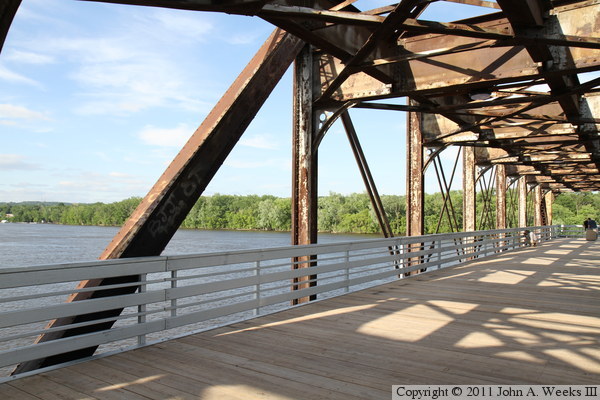
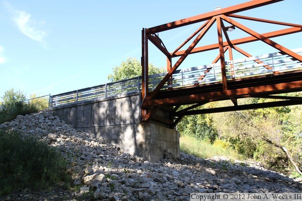
These two photos are views of the downstream south face of the bridge
spans. The photo above is taken from near the bridge abutment and shows
the new spans in the foreground. The photo below is taken from the edge
of the river and feature the 1894 bridge spans.
The photo above is looking north towards the western of the two new bridge
spans. Notice the crystal clear blue sky in the background. The photo
below is looking northeast towards pier #2 and the transition between the
new and old bridge spans.


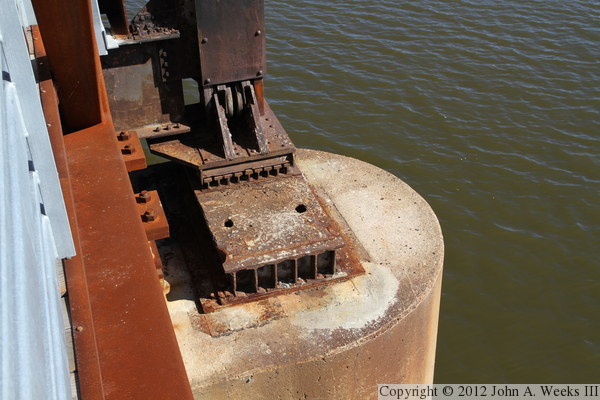
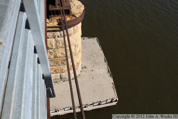
The photo above is pier #1 where the two new spans meet. The photo below
is a closer view of pier #1. This pier is in the best condition of the
three remaining cut stone piers. Notice the reinforcing rod that is holding
the top cap together, and the remains of the bridge bearing from the 1894
spans that were removed.

The photo above is the top of pier #2 where the old and new spans meet.
This shows that the new spans are narrower than the old spans, and thus,
the old bearing plates were not reused for the new truss sections. The
photo below is looking north towards the west bridge abutment. This is a
difficult photo since the abutment is in a shadow, but the background is in
the bright sun.
The photo above is pier #4 at the far east end of the bridge. This pier
is wrapped in concrete from its base up to just above the waterline. The
photo below is pier #3. This pier is also wrapped in concrete, but only
the very top of the cut stone is still visible above the concrete.

|
